Zeroing in on Life Around a Hydrothermal Vent
Vicki Ferrini has spent a lot of time working on mapping the ocean floor, and now she’s sailing in the South Pacific to get a closer look.
Vicki Ferrini has spent a lot of time working on mapping the ocean floor, and now she’s sailing in the South Pacific to get a closer look.
Ferrini, who works in the Marine Geology and Geophysics Division of the Lamont-Doherty Earth Observatory, is sailing aboard the Schmidt Ocean Institute’s R/V Falkor. Scientists aboard the research vessel are exploring the life around hydrothermal vent systems 2,400 meters beneath the surface of the South Pacific Ocean. And, they’re blogging about it.
Ferrini posted the latest dispatch at the American Geophysical Union website. The ship is hovering over the Lau Back-arc Basin, between Tonga and Fiji and next to the Tonga Trench, where the Pacific plate drives under the Australian Plate.
The video above takes you there via some sophisticated mapping to one of the thermal vents that they are studying.
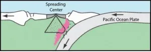
Ferrini writes: “The hydrothermal vent fields we are studying on this cruise are located along spreading centers on the overriding plate. The relative proximity of the subduction zone to the spreading center has effects on the geology, geochemistry and ecosystems of the vent fields we are studying. The shape and characteristics of the seafloor itself are also affected.
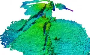
“Maps that describe the shape of the seafloor (also called ‘bathymetry’), are a fundamental component of our research during this cruise. These maps will provide geologic context for the ecosystems being studied, and will allow us to look for changes in the seafloor that may have occurred since the area was last mapped a decade ago. Changes, if they exist, could be due to volcanic or tectonic events that could not only reshape the seafloor but also dramatically affect the organisms living there.”
Read the full post here. You can read other posts and follow the expedition here, and track the R/V Falkor’s progress here.
Look here on State of the Planet for a story about Ferrini and the ongoing work of mapping the ocean floor.