The weight of ice
Taking off amidst snow flurries we are headed completely across the Greenland ice cap to the northeast corner of of the country. This flight will differ from most of the DC-8 flights during the Ice Bridge 2010 Greenland campaign. The DC-8 flights are mainly used to measure sea ice or surface mapping with high altitude… read more
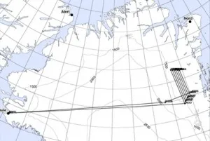
Taking off amidst snow flurries we are headed completely across the Greenland ice cap to the northeast corner of of the country. This flight will differ from most of the DC-8 flights during the Ice Bridge 2010 Greenland campaign. The DC-8 flights are mainly used to measure sea ice or surface mapping with high altitude LVIS (a laser swath-mapping instrument). The P-3 aircraft flights, scheduled for later in the program, are better suited for the surveys of glaciers, as the plane is slower and smaller. Today’s flight, however, is a low altitude survey flight over the Northeast Ice Stream, an area where satellites suggest that the thinning of the ice cap is just beginning. Our Ice Bridge 2010 studies will provide a baseline to assess future changes. There are four flights to this area in the plan, two on the DC-8 to survey the ice stream and 2 on the P-3 aimed at the glaciers.
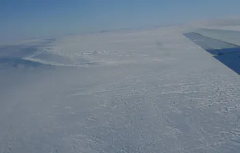
Flying 1500 feet above the ice we skim low over an area of dunes and ridges carved on the ice surface by the wind, but flat with almost no larger-scale relief. The ice penetrating radar shows about 2.5 Km (8200 feet) of ice in the center of Greenland and about 1.2 km (a little under 4000 feet) of ice near the edges. With altitude in the center of Greenland ~ 8000 feet, this places the rocky surface under the ice near or below sea level. Most people would be surprised to hear that under the ice Greenland is shaped like a bowl, low in the center and rising toward the mountains on the coast. The low in the center is largely due to the weight of the ice, causing the Earth’s crust to bend and sag under it.
Reaching the mountains along the eastern coast, we begin our grid survey, flying long lines parallel to the coast and the mountains. Each line is spaced 10 km further inland, so as morning moves into afternoon the mountains become smaller and more distant. Before wrapping up we fly down the center of two glaciers that drain the ice stream. We are measuring for change in Zachariae and in 79°North Glacier (easy to locate on a map by its name). Earlier surveys show Zachariae Glacier had accelerated in thinning from ~ 1m a year in 2000 to ~2.5 m a year in 2009. Our low flight down the center of each of these glaciers measures for any further changes before heading ‘home’ to Thule!