Scientists Respond to Earthquakes in Malawi
In December, nearly a dozen earthquakes of magnitude 5 or greater rattled the southeast African nation of Malawi, killing four, injuring hundreds, and making thousands homeless. The region had been calm for decades, so the earthquakes caught everyone by surprise. But aftershocks continue, and more quakes can be expected. Seismologists from Columbia University’s Lamont-Doherty Earth Observatory traveled to Malawi to help assess the risk. Read about their journey here. […]
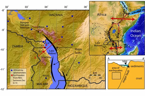
In December, nearly a dozen earthquakes of magnitude 5 or greater rattled the southeast African nation of Malawi, killing four, injuring hundreds, and making thousands homeless. The region had been calm for decades, so the earthquakes caught everyone by surprise. But aftershocks continue, and more quakes can be expected. Seismologists from Columbia University’s Lamont-Doherty Earth Observatory traveled to Malawi to help assess the risk. Read about their journey here.
Malawi, a landlocked, agrarian country, is located on the East African Rift—essentially a giant, slowly spreading crack 2,400 miles long. The rift has produced major quakes in Malawi, and across East Africa. Malawi currently has just two seismic stations and few seismologists trained in modern analysis techniques, hampering the country’s ability to map faults and assess their danger. Before the earthquakes hit, scientists at Lamont had proposed a major study of this region, to begin in 2011, in collaboration with the Geological Survey of Malawi and other US and African institutions. But when the ground in northern Malawi´s Karonga region began to shake, a more timely response was needed. Lamont seismologists James Gaherty and Donna Shillington arrived on New Year’s Day with five seismometers to record the aftershocks and map the fault locations. They have since worked closely with their African colleagues to assess future risk.
This rapid response effort was made possible by Lamont-Doherty and the Earth Institute, which funded the initial deployment; Incorporated Research Institutions in Seismology (IRIS) and Cindy Ebinger, a seismologist at the University of Rochester, who provided seismic instrumentation; and the National Science Foundation.