More Intense Non-Tropical Storms Causing Increased Rainfall in U.S. Southeast
In the Southeastern United States, the increasing amount of rain during hurricane season is coming not from hurricanes but from non-tropical storms created by weather fronts, new research finds.
By Abigail Eisenstadt
In the southeastern United States, the increasing amount of rain during hurricane season is coming not from hurricanes but from non-tropical storms created by weather fronts, new research finds.
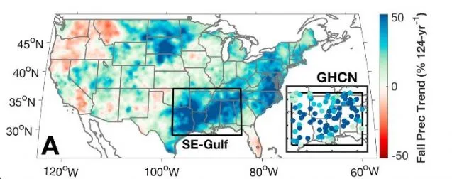
A new study in the journal Geophysical Research Letters examined the region’s precipitation records from 1895 to 2018. The research found precipitation in the Southeast during the fall increased by almost 40 percent in the past century due to an increase in average daily rainfall rather than the overall number of storms.
Rising precipitation rates came from heavier frontal storms rather than tropical cyclones. These frontal storms pulled in moist air from the Gulf of Mexico at an increased rate, according to the new study.
“This could have serious implications for flood risk down the road, particularly because the Southeast contains many areas susceptible to extreme flooding,” said Daniel Bishop, a bioclimatologist at Columbia University’s Lamont-Doherty Earth Observatory and lead author of the study.
In the study, Bishop and his colleagues first wanted to know whether the Southeast’s fall precipitation increase came from periods of more intense rain or more frequent periods of rain. They took data from 99 weather stations around the region and found the total fall precipitation increased because rainstorms became heavier. The frequency of rainstorms did not increase, but the intensity of the storms did.
The researchers also wanted to know what type of storm was bringing the intense rainfall. From the weather station data, they found roughly three-quarters of the rainfall increase came from frontal storms.
Frontal storms rely on weather fronts, phenomena that occur when air masses with different temperatures meet. The North Atlantic Subtropical High, a large, circling body of high-pressure air located near Bermuda and the Gulf of Mexico, sends winds from the Gulf of Mexico into the Southeast. These winds supply the moisture that fuels frontal storms.
Weather patterns in the region are changing in the fall, a season typically known for its tropical storms. The North Atlantic Subtropical High’s conveyor belt of moisture has sped up, causing winds from the Gulf of Mexico to transport water vapor to the Southeast faster. This transported water vapor condenses into precipitation as frontal storms pass through the Southeast.
Scientists predict global humidity will rise in the coming century as climate change progresses. That means there will be more water vapor in the air. The North Atlantic Subtropical High’s increased winds could add to this increase in global humidity, leading to more rainfall than expected in the region, according to the study’s authors.
Most of the eastern United States, a region whose rainfall is affected by the North Atlantic Subtropical High, may experience even more intense rainstorms if these trends continue. These areas may not have adequate infrastructure for the resulting increase in flood risk, Bishop said.
The paper was coauthored by Park Williams and Richard Seager, also of Lamont-Doherty.
Abigail Eisenstadt is a science writing intern at the American Geophysical Union, which published the study. Follow her on Twitter: @aeisenstadt1