Mapping Water Circulation Within Cascadia Basin
Heading west from coastal Oregon we are able to make our initial seismic images beneath the seafloor continuously as we go. Where once our data would have been recorded on magnetic tapes only to be analyzed long after the expedition was over, thanks to the wonders of modern signal processing, we can now make images… read more

Heading west from coastal Oregon we are able to make our initial seismic images beneath the seafloor continuously as we go. Where once our data would have been recorded on magnetic tapes only to be analyzed long after the expedition was over, thanks to the wonders of modern signal processing, we can now make images almost immediately as the signal is detected at our hydrophone receiver array. For most of us looking at these images, all the action begins at the seafloor and below. But there is the whole deep ocean above and for some members of our science team, this is the primary subject of interest.
Berta Biescas from Dalhousie University and her student Guillermo Bornstein will be using the seismic data we are collecting to study the ocean currents that circulate within the water mass above the Juan de Fuca plate. Within the Cascadia Basin, as this region is known to oceanographers, the great eastward flowing North Pacific Current arrives from the other side of the Pacific Ocean, and is deflected by North America, splitting into the north flowing Alaskan Current and the south-directed California Current. These water movements lead to upwelling along the coastal zone of nutrients from the deeper ocean that then supports the abundant marine life of the region.
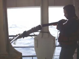
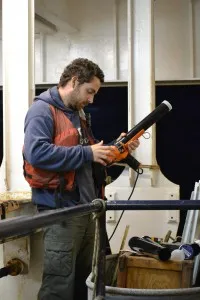
With the high density of our soundings and the high fidelity of our recordings we can actually image reflections within the ocean that arise from small changes in temperature and salinity associated with these currents and upwelling water masses. To help understand these reflections, we are taking very closely spaced measurements of the temperature and salinity of the ocean using eXpendable Bathy -Thermograph probes. Every 10 minutes along our track Berta and Guillermo load up the XBT launcher and send one into the ocean. As the probe descends through the water column it relays back to the ship measures of temperature and salinity.
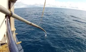
A good XBT is a deep one – some record to estimated depths of 2000 meters below the sea surface, two thirds or more of the ocean depth in this region. Later these measurements, along with other data from our cruise, will be sent to national data centers, where they may be used for additional studies, contributing to our knowledge of the temperatures of the global ocean.