Haiti: Physics of Quakes Past, and Future
The earthquake that struck Haiti took place along what is called a strike-slip fault—a place where tectonic plates on each side of a fault line are moving horizontally in opposite directions, like hands rubbing together. When these plates lock together, stress builds; eventually they slip; and this produces shaking. This quake was fairly shallow; it… read more
The earthquake that struck Haiti took place along what is called a strike-slip fault—a place where tectonic plates on each side of a fault line are moving horizontally in opposite directions, like hands rubbing together. When these plates lock together, stress builds; eventually they slip; and this produces shaking. This quake was fairly shallow; it involved compression of the plates directly against each other as well as sliding; and it occurred near the densely populated capital of Port-au –Prince. This is a deadly combination, but large, sudden movement was not the only thing; because buildings in this impoverished country were not made to withstand heavy shaking, the destruction was extraordinary. Below, Arthur Lerner-Lam, head of the division of seismology, geology and tectonophsyics at Lamont-Doherty Earth Observatory, discusses details quake physics and what might happen next.
How powerful was this event?
Magnitude 7.0 on the Richter scale is the measurement used in the official U.S. Geological Survey summary. However, seismologists use different ways of measuring magnitude for these very large events. You may see references to a “moment magnitude.” On that scale, this one is estimated at 7.1. Technically, this is a more accurate measure and is closely related to other measures of earthquake strength, such as its slip (movement of crust), and the length of the rupture. Each magnitude increase means an earthquake shakes the ground with 10 times more the amount, or amplitude, than the next lower number. So, an M7 is 10 times shakier than an M6. But the relationship between amplitude and energy means that an M7 is actually 30 times more energetic than an M6.
Where did it occur?
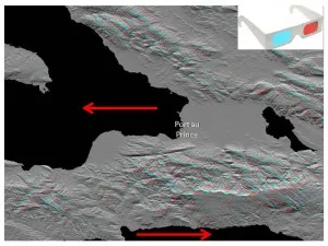
The epicenter, or the point on the earth’s surface above the nucleation of the event, was about 25 kilometers, or 15 miles, southwest of Port-au-Prince. When you add depth–13 kilometers, or 8.1 miles — you have the “hypocenter.” However, large earthquakes are not point phenomena: they rupture a fault with a measurable length and width. Though final measurements have not yet been made, this rupture is probably about 75 kilometers (30 miles) in length and 13-15 kilometers in width. We estimate this in the early days from the distribution of aftershocks and measurements of complexities in recordings of the earthquake from nearby seismometers.
Were there warning signs, and will there be signs of future danger?
A global system of seismic instruments run by many institutions routinely detects sizable quakes anywhere. But there are no such stations in Haiti, and not even any local system there. So, there have almost certainly been many small events near Port-au-Prince both before and after the big quake, but they have not been picked up. The closest seismometers are reporting from the Dominican Republic, Jamaica and other nearby countries. That said, no matter how many instruments you have, scientists still do not yet have a reliable way to predict the timing of an earthquake. In this case, there was no evidence of precursory activity that could have delivered a short-term warning.
How frequent are aftershocks, and how dangerous are they?
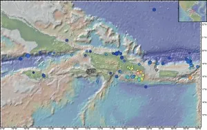
Once there is a big quake, the earth keeps rearranging itself for a while, so there is heightened risk of more, smaller quakes in following weeks, months and even years. Typically, as time goes by, the intensity and frequency taper off. There were 45 aftershocks in just the first three days with a magnitude of more than 4.5. The largest four had magnitudes ranging from 5.5 to 5.9, and all occurred in the first eight hours after the main shock. The biggest one so far—magnitude 6.1– hit a week after the main shock and caused panic all over again. There will be more.
What do we know about faults around here?
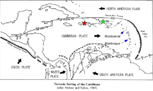
The existence of dangerous faults in this region is not a surprise. Published studies have documented their locations, and strain building on them. This earthquake came along a fault that forms part of the boundary between the Caribbean plate (to the south) and the North American plate (to the north). Relative to North America, the Caribbean plate moves east at about 20 millimeters a year, or slightly less than an inch. This is about half of the rate of motion between the plates that underlie California. However, this motion is divided among at least two and probably three major faults, running east-west. The main shock occurred on part of what is known as the Enriquillo-Plantain Gardens fault, which follows the peninsula of southern Haiti, then continues offshore westward to Jamaica. Recent measurements show that it is building up strain at about 7 millimeters a year. The other major one is the Septentrional fault, running parallel to the Enriquillo along the northern side of the island of Hispanola (which Haiti shares with the Dominican Republic). The Septentrional continues westward to the southern coast of Cuba. Well-developed strike-slip faults often “lock” in place, with little evidence of activity except for large earthquakes that occur several hundred years apart. The system around this region has not been totally inactive; it has seen dozens of earthquakes of at least magnitude 5 since 1964. But the last big one we know of on the Enriquillo fault was in the late 1700s.
Is there danger to the Dominican Republic or other nearby countries?
The fault appeared to rupture to the west, starting from the hypocenter, away from the Dominican Republic. The Enriquillo fault does indeed continue to the east, though there is some question as to how far. The relative motion of the plates is transferred to the northern branch of this fault system, along the northern coast of the Dominican Republic. The Dominican Republic has been struck by large earthquakes in the past, but not this time; shaking is generally greater closer to the rupture. More generally, though, there are often interactions among such closely spaced faults, which can trigger new earthquakes. One of the questions being addressed now is whether the sudden release of stress in the Haiti earthquake has adversely affected other faults in the region, which may hasten the occurrence of another earthquake along those faults. This kind of triggering has been observed along the North Anatolia Fault in Turkey in 1999, in Sumatra in 2004-2005, and elsewhere. There’s speculation that this happened along the Enriquillo fault in the late 18th century, though definitive geological mapping has not yet been done.
Why was damage so great; can’t places like Haiti be made less vulnerable?
A strike-slip earthquake produces lots of lateral shaking, and that is very damaging to buildings. Strike-slip faults also produce shallow earthquakes, which are more damaging simply because they are closer to the surface, where people live. But the earthquake itself is only part of the answer. This was roughly similar to the 1989 quake that hit the San Francisco area while the World Series was going on. There, only several dozen people died. Much of the difference can be attributed to construction practices. Haiti is very poor, and had a lot of weak buildings, sitting on soft soils. That is a disastrous combination. This is not a new lesson. Plenty is known about how to build strong buildings, but application of this knowledge is of course problematic in less developed countries. Attention is now being paid to saving lives and providing the immediate necessities of water, food, medicine and temporary housing. Haiti is exposed to other hazards, including hurricanes and landslides—and we have to watch out for landslides triggered by aftershocks, especially if it rains in the coming days. But the long-term rebuilding program–perhaps decades long–must try to use best practices, fine tuned to Haitian society. “Multihazard resilience” is a touchstone concept for developing countries. Resilience is as much a statement of civic and cultural strengths as it is a reflection of a well-built infrastructure.
Related resource: Haiti Earthquake, Crisis and Response (Congressional Research Service)