Waterfront Development Added Billions to Property Values Exposed to Hurricane Florence
Rapid development in flood-prone zones during recent decades helped boost the amount of property exposed to the 2018 hurricane substantially, a new study says.
Rapid development in flood-prone zones during recent decades helped boost the amount of property exposed to 2018’s devastating Hurricane Florence substantially, a new study says. It estimates that the value of property in North Carolina and South Carolina potentially exposed to flooding at $52 billion—$42 billion more than at the start of the century (in 2018 dollars). While much development took place between 1950 and 2000, financial risk rose quickly afterward because much of it clustered along coastlines and adjacent to rivers and lakes, where buildings were more vulnerable to flooding.
“There is a surge in urban expansion in the Carolinas, starting in the 1950s, that increased almost exponentially the value of properties exposed to the flooding created by Florence,” said lead author Marco Tedesco, a climate scientist at Lamont-Doherty Earth Observatory. “This was especially accelerated after 2000.”
Published this month in Natural Hazards and Earth System Sciences, the study is the first to examine the evolution of development in coastal areas in relationship to hurricanes and flood risk. Understanding the impacts of extreme weather on infrastructure may help mitigate the economic harm associated with flood and storm damage, the authors say.
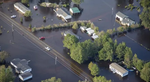
Hurricane Florence made landfall in North Carolina in September 2018. The storm caused $24 billion in property damage across four states, according to federal estimates, primarily through extreme rainfall and the flooding of buildings in the storm’s path. Large and slow-moving, Florence dumped more than two feet of rain on parts of eastern North Carolina and caused a storm surge of up to 10 feet to inundate coastal areas.
Using Federal Emergency Management Agency maps of storm flooding along with satellite imagery of the region captured after Florence, and linking these to property value data, Tedesco and co-authors Jeremy Porter from the City University of New York and the Columbia Mailman School of Public Health, and Steven McAlpine of the First Street Foundation created a first-of-its-kind maximum flood extent map for the area battered by the hurricane.
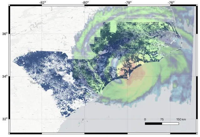
Climate change is likely to make storms like Florence more frequent and severe, with worsening impacts due to sea level rise and heavy rainfall. Experts agree that building on property close to water is unwise due to the high risk of damage from storms, floods, and sea level rise. The map reveals that people in the Carolinas have yet to heed this warning.
The study complements a larger effort, sponsored by the Columbia University Research Initiatives in Science and Engineering competition in collaboration with the Columbia Business School, to develop and improve real estate models used to estimate how housing prices change. The models are generally based on number of rooms, services, neighborhood quality, water views, and other such factors and typically don’t include how climate variables such as heavy rainfall and storm surge flooding affect home values.
Tedesco aims to change that by augmenting existing models or developing one that includes real estate behavior based on data from approximately the last 20 years, where a growing number of extreme weather events occurred. Because humans, landscapes, and weather hazards interact in dynamic ways, unraveling these relationships and figuring out how to model them involves geographers, economists, urban planners, and insurance and real estate experts.
“We want to see what we can learn in terms of people’s behavior when it comes to real estate and how that relates to climate change and, in particular, floods,” said Tedesco. “It’s the feedbacks among these that matter, so modeling those is the long-term goal of our work.”
He added that modeling these feedbacks also involves learning how much of the increased exposure to extreme weather can be associated with urban development rather than the actual strength of a storm’s impact.
Tedesco would like the new real estate model to address the social cost of climate change on communities, especially low-income neighborhoods whose residents may lack flood insurance and the resources to recover from devastating storm impacts. Policy and other decision-makers could use the model as a tool to identify vulnerable communities and help them plan and understand risk.
“It’s important to know what will happen to the climate in the next 100 to 200 hundred years to preserve humanity and the planet,” said Tedesco. “But for the short term, it’s the coming five or ten years that matter for homeowners and the real estate market because that’s the timescale of how quickly things could change.”
Carolynne Hultquist of Lamont-Doherty Earth Observatory contributed to the study. The First Street Foundation and the Columbia University Research Initiatives in Science and Engineering competition funded the research. This post was first published by the Center for Climate and Life, a research initiative based at Columbia University’s Lamont-Doherty Earth Observatory.