Temporary Seismic Networks Can Help Developing Nations Pinpoint Quakes
Earthquakes can be devastating, as Haiti has shown. They can trigger tsunamis, like the one in Indonesia in 2004, and create enough ground shaking to topple buildings. Aftershocks can prevent people from returning to their homes for weeks, even months. The immediate response to a natural disaster is to search for those lost, treat the… read more
Earthquakes can be devastating, as Haiti has shown. They can trigger tsunamis, like the one in Indonesia in 2004, and create enough ground shaking to topple buildings. Aftershocks can prevent people from returning to their homes for weeks, even months.
The immediate response to a natural disaster is to search for those lost, treat the injured, and to provide food and shelter for the displaced. But scientists can also play a role, in pinpointing where the earthquake originated, and determining if other quakes will hit. The developed world is able to analyze earthquakes almost instantly. The US Geological Survey runs a permanent network of instruments in quake-prone areas like the San Andreas fault. But many developing countries are not as lucky. Both Malawi and Haiti sit in active seismic zones but neither has a national seismic network.
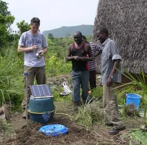
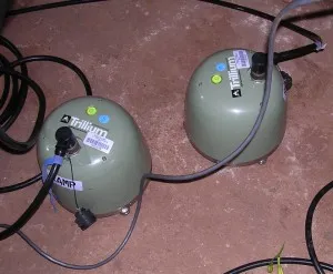
One solution is to install a temporary network of instruments and record the aftershocks. IRIS, a consortium of US academic institutions, maintains a fleet of instruments ready to be deployed around the world. Most aftershocks are too small to be felt but with the right instruments scientists can use them, over a two to six month period, to map the features below the earth’s surface to understand the tectonics of the region.
To set up a temporary network, scientists need to know the area and have contacts on the ground ready to help put instruments in the field. They also need funding, and access to the region. Our biggest logistical challenge was in getting our equipment to Malawi. Haiti, by contrast, has been so devastated by the recent earthquake that scientists were unable to respond with the proper instruments at first; efforts are just beginning.
Short term projects like the one in Malawi can have long-term impact. We are able to share our equipment and expertise with local scientists while giving the country a better sense of future earthquake hazards. Ideally, these loaned instruments can motivate the government to establish a network of its own.