Seeing Through the Sea
How researchers are plumbing the seafloor during a quest to understand ‘silent’ earthquakes off the Mexican coast.
Sunlight entering the ocean will only travel about 200 meters below the surface before there is little to none left, leaving the deepest parts of our oceans in perpetual darkness. While these vast regions of our Earth might be out of sight, on R/V Langseth, they are neither out of sight nor out of mind, thanks to a multibeam echo sounder which illuminates down to the seafloor. This is one of the many additional geophysical datasets we are collecting while at sea that complement the controlled-source seismic portion of the expedition.
The multibeam echo sounder is a highly sensitive instrument that is mounted to the hull of the vessel and emits a complex sound wave that travels through the water column, reflects off the seafloor, and gets recorded back at the ship — just like when you yell “echo” in a big canyon and listen for your own reply. The time it takes for the sound wave to travel through the water column is used to determine the depth of the seafloor. However, we need constraints on the speed of sound through the water column to more accurately determine the depth of the seafloor, and the speed at which sound travels through water is influenced by temperature. On this expedition, we have been using an expendable bathythermograph, or “XBT” for short, to measure the temperature of the water column in order to precisely constrain the depth to the seafloor.
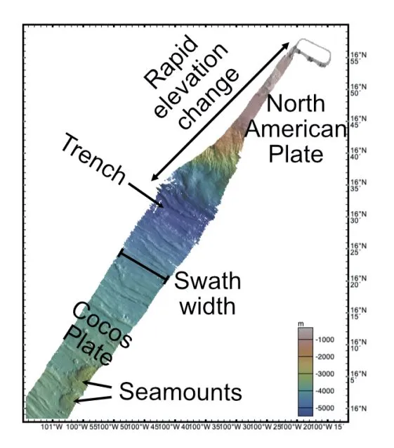
A simple sound wave would only get us one point beneath the ship, barely covering any of the seafloor, and taking significantly longer to acquire the same kind of dataset we have now. Instead, R/V Langseth’s multibeam echo sounder emits a fan-shaped acoustic wave beneath the ship and can extract directional information of the returning soundwave to produce a swath of depths with hundreds of datapoints per soundwave. Since the take-off angle of the fan is fixed at the ship, the water depth mainly determines how much of the seafloor we will spatially be able to look at. In shallower waters, the acoustic wave doesn’t have a chance to fan out as far, producing a narrower band of data points. This can be easily seen below, where we plot some of our data crossing the trench, going from about 100 meters deep near shore to more than 5,000 meters at the trench.
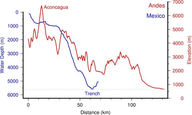
We use the data not only to find where the seafloor is, but to help us understand the local geological processes occurring in the region. With this depth data, we can find canyons cutting through a steep forearc, the narrow trench axis, abyssal hill fabric, and seamounts littered across the seafloor. To better demonstrate how incredible some of these seafloor features are, we can take a single profile through from the trench towards shore and compare it against a terrestrial feature, such as the Andes Mountain range:
Brian Boston is an associate research scientist at Columbia University’s Lamont-Doherty Earth Observatory.