Sea Level Rise: A Crash Course for All
Lamont-Doherty Earth Observatory presents a public lecture on the driving forces and dynamics reshaping global coastlines.
The latest and most comprehensive Intergovernmental Panel on Climate Change (IPCC) report holds dire warnings. The report details how humans have been responsible for the 1.1 degrees C of temperature rise since the industrial era. It also shows the impacts of this warming are already lethal and disproportionately harming the world’s most vulnerable people. But there is also hope. The report concludes that it is still possible to hold off global warming’s worst consequences, but doing so will take global cooperation, billions of dollars, and profound societal changes.
With such high stakes, a lecture at Columbia Climate School‘s Lamont-Doherty Earth Observatory, “How Much Will Sea Level Rise? Diving into the Past to Predict Future Change,” drew a near-capacity crowd last week. Assistant Professor Jaqueline Austermann, an affiliate of the Seismology, Geology, and Tectonophysics Division of Lamont, delivered the talk.
“[Jacky] is an incredibly well-recognized young scientist,” said Lamont director and Columbia Climate School co-dean Maureen Raymo, who introduced the lecture. “She was named one of Science News’s 10 scientists to watch last year. She is the winner of a Sloan Research Fellowship in 2021 to 2023, a prestigious fellowship given to scientists.”
Austermann framed the conversation by first describing the stakes — how sea level threatens infrastructure worldwide, and the homes and livelihoods of millions of people. Then she dove into the evidence.
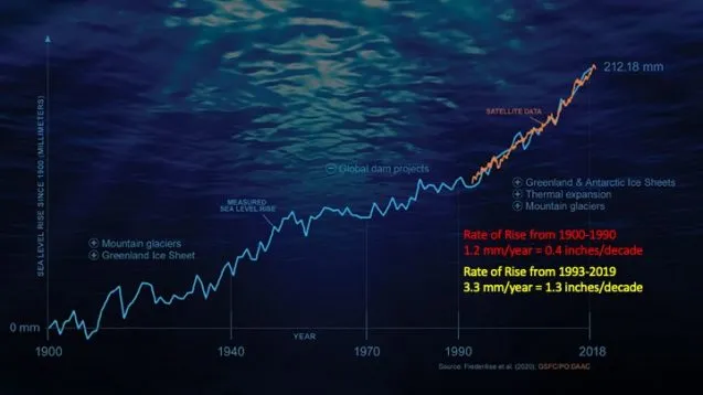
“If we look at [the rate of sea level rise from] 1900 to 1990, we’re looking at about half an inch of sea level rise per decade, or a little over a millimeter per year. And that has been accelerating to three to three and a half millimeters per year over the last couple of decades,” said Austermann, pointing to and describing the various measurement technologies.
Austermann explained that sea level rise is a consequence of three dynamics: roughly a third of that sea level rise comes from thermal expansion (as global warming heats the oceans, water naturally expands), whereas melting polar ice in Greenland and Antarctica and the melting of mountain glaciers are responsible for the other two thirds.
Looking closer at polar ice melt, Austermann noted that the Thwaites Glacier in Western Antarctica is the most significant concern to scientists.
“There’s good evidence that if it starts to melt, big parts of this Western Antarctic ice sheet will [also] melt,” she explained.
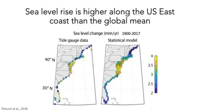
The talk also drilled down how and why sea level doesn’t rise at the same rate everywhere. On the East Coast, for example, the sea is rising at roughly double the global rate. And even along the same coastline, this acceleration is not uniform.
“We have about two millimeters per year of sea level rise in Florida over this time period and about four in the Carolinas,” said Austermann. “So, there’s very significant spatial variability in this sea level prediction, and that also means that when we’re planning and adapting infrastructures for sea level change, this spatial variability is really critical.”
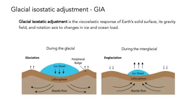
Austermann said this variability could be traced back to the last ice age and how land masses gradually rebound once relieved of their burden of ice. When ice sheets covered huge swaths of North America, their weight depressed the land under the ice, and caused the surrounding land to bulge up. Now that the ice has disappeared, the land formerly under the ice sheet is slowly rising back up and the surrounding bulges are lowering, flattening out. This so-called “post-glacial rebound” changes the coast’s character and relationship to rising seas.
“Sea level is going up, and it’s going up because of expansion but also because the land is coming down. This is most severe in the Carolinas because of this very distinct shape,” said Austermann.
Climate researchers project a range of future sea levels. Austermann displayed a map showing what the different predictions mean in terms of inundation.
Digging deeply into paleoclimatology, the study of past climate, Austermann described how Lamont scientists — herself and Raymo included — have been able to model predictions of future sea level rise by studying the markers of past tides, gauging sea levels during a time when Earth was warmer than today. Specifically, Austermann shared photos and data from a field expedition in the Bahamas. While there, the research team found clues to sea level rise in the distant past by examining fossilized dunes and corals. They concluded that sea level back then was likely at least two millimeters higher than today and may have risen as much as five millimeters higher.
Among her final comments was a daunting conclusion. Sea level rise is projected to be on the order of a meter in New York City by the end of the century, reminding the audience of the critical importance of reducing carbon emissions to stave off the most drastic global changes.