Researchers Probe Bottom Off Port-au-Prince
Scientists are now sailing off the coast of Haiti to assess the recent earthquake there, and the potential for more. This is the latest update, emailed by chief scientist Cecilia McHugh from the research vessel Endeavor. (Read the full story of the project, involving the Earth Institute and other major institutions.) The first part of the science program focused… read more
Scientists are now sailing off the coast of Haiti to assess the recent earthquake there, and the potential for more. This is the latest update, emailed by chief scientist Cecilia McHugh from the research vessel Endeavor.
(Read the full story of the project, involving the Earth Institute and other major institutions.)
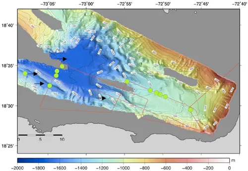
The first part of the science program focused on a deep water survey of Canal Du Sud, near Port-au-Prince, from water depths of 1000 to 1750 meters, based on multibeam bathymetry provided from a previous survey by Bernard Mercier le Piney and his team. The main objectives are to understand the origin of unusual topography formed by ridges and canyons oriented oblique to the trace of the Enriquillo fault, rather than in a downslope direction. We surveyed these features with chirp [sonar] during the night and cored a series of basins where we suspect earthquake-related events such as gravitational flows and mass wasting could have accumulated. A major goal is to find evidence for the January 12 earthquake and other historical seismic activity. We recovered a transect of gravity cores, average length of 1.5 m, across a deep basin, or “depocenter.”
Initial observations showed at least three events marked by dark layers in all cores at similar depths. Short-lived radioisotope and radiocarbon dating will test this hypothesis. Sediments will also be cored in two ~2 kilometer-long basins associated with a 200-meter-high ridge that is 10 km long and appears to be tectonically controlled. The goal here is to document evidence of tectonic activity [that might be] manifested as displaced sediment layers and synchronous gravitational flows and mass wasting.
The second phase of our program will consist of shallow-water surveys of the eastern and southern margins of the Baie de Grand Goave, west of Port-au-Prince, where the Enriquillo fault has been mapped. We will look for evidence of a rupture and tsunami. The shallow water multibeam, side-scan sonar and chirp will be deployed for this survey, planned for March 3-4. The side scan sonar was tested in the Baie du Port au Prince revealing mounds, possibly bioherms, and pockmark features. If gas and fluid releases occurred associated with the fault, the side scan sonar will be an excellent tool to document these features and others.