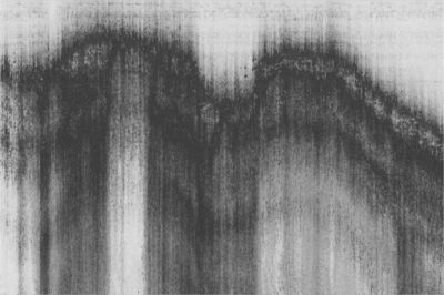
Another world lies beneath the Hudson River, as scientists have shown using pulses of sound to map the bottom. In recent years, the bathymetry maps developed at Lamont-Doherty Earth Observatory and Stony Brook University have turned up hundreds of shipwrecks and a new channel off Battery Park City, drawing interest from treasure hunters and mariners alike. Now a new group is finding inspiration: artists.
The maps of the river bottom, and the sonar that produced them, will be featured in a floating exhibit, “Sound in the Frying Pan,” taking place on a historic lightship docked in Manhattan’s Chelsea neighborhood, May 15-17. The show will feature several musical “compositions” loosely designed for the space: the Hudson River measurements as well as sounds inspired by the weather and the boat’s rocking motion.
Coincidentally, the mapping project, done in part by Lamont oceanographers Frank Nitsche and Bill Ryan, is also featured in a New York magazine article this week about weird stuff on the river bottom, from silver ingots and cement-eating worms to a wrecked freight train.
Melissa Clarke, a multi-media artist in Brooklyn, was surfing the Internet several months ago when she came across the Hudson River Benthic Mapping Project, which was commissioned by New York’s Department of Environmental Conservation and carried out by Lamont, Stony Brook, Queens College and the Cary Institute of Ecosystem Studies.
For years, Nitsche and his colleagues traveled up and down the Hudson, taking samples of sediment and bouncing pulses of sound off the bottom, to get a detailed picture of the topography below. In 2004, they finished mapping 150 miles of riverbed, from Troy to the Verrazano-Narrows Bridge.
By the time Clarke contacted Nitsche, most of his research had shifted to west Antarctica, where he is mapping the bottom of the Amundsen Sea to learn more about thinning glaciers there. Nitsche still had the Hudson River data on his computer, though, and sent Clarke maps of New York Harbor, as well as the sound files that produced it.
The beauty of the images surprised Clarke. “It turned out the sub-bottom is like an inky sand art,” she says. “Or a Chinese brush painting of mountains.”
The artist has turned those images into a short movie that will play continuously on the Frying Pan’s bottom deck. The related acoustic recordings will double as a sound track.
Some might wonder if grainy images of the Hudson riverbed constitute art. That question has occurred to Nitsche, whose own artistic taste leans toward impressionism. As the scientist scrolled through the images on a recent morning, their aesthetic dimension seemed lost on him. Nonetheless, he says he’s pleased they will be on display, where they might strike someone’s curiosity. “That’s always good,” he says.
“Sound in the Frying Pan,” Pier 66 Maritime, Hudson River Park at 26th Street
Friday night opening, May 15, 7 pm, $15/$10 students
Saturday and Sunday, May 16-May 17, 12 pm to 9 pm, Admission Free

