Investigating Giant, Unseen Landslides
Steep mountains produce some of the biggest landslides on earth but in such rugged terrain who’s around to notice? These monster back country slides are now gaining attention from far-away scientists, aided by a global network of seismic stations, earth-orbiting satellites and the crowd-sourcing power of the internet.
Steep mountains produce some of the biggest landslides on earth but in such rugged terrain who’s around to notice? These monster backcountry slides are now gaining attention from far-away scientists, aided by a global network of seismic stations, earth-orbiting satellites and the crowd-sourcing power of the internet.
Once a month or so, a landslide packs enough power that it moves the global seismic network’s needles. In May, seismographs recorded two massive slides–in the Himalayas of Nepal and Saint Elias Mountains of Alaska. From computers in Palisades, N.Y., scientists at Columbia University’s Lamont-Doherty Earth Observatory analyzed the evidence to piece together both events.
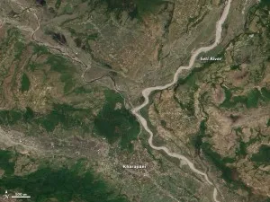
In Nepal, a flash flood on May 5, in the popular Annapurna trekking region near Pokhara, swept away an entire village. News reports suggested that a huge landslide might have blocked the Seti River, triggering the flood. Colin Stark, a geophysicist at Lamont-Doherty, read the story on landslide expert David Petley’s blog and wondered if the event had been big enough to generate seismic waves. Stark and his Lamont colleague, Göran Ekström, checked Lamont’s catalog of big earthquakes. Sure enough, the Global Seismic Network had picked up the signal at about 9:10 am on May 5, 2012. “You could tell right away it didn’t look like a tectonic event,” said Stark. “This was a landslide.”
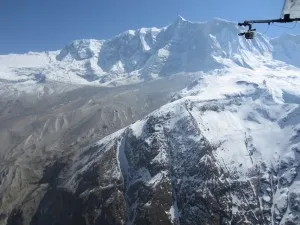
By analyzing surface-wave recordings of the event, Stark and Ekström were able to pinpoint where the landslide started, what direction the rocks fell in, and how fast. They estimate that some 780 million cubic feet of rock broke off a ridge a mile-and-a-half from Annapurna IV’s 25,000-foot summit. The rocks plunged about a mile westward before picking up ice and snow on their slide into the Seti’s headwaters at about 160 miles per hour. The initial rock fall generated surface waves equivalent to a magnitude 5 earthquake.
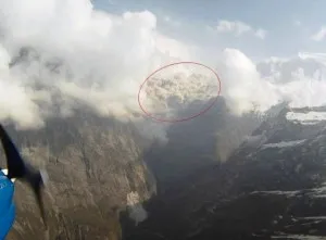
.The avalanche kicked up a massive cloud of dust that a pilot with the sightseeing business, Avia Club Nepal, happened to film on a wing-mounted camera while flying through the valley. The time stamp on his video provided additional evidence that the landslide and flood happened in quick succession. Since then, NASA satellites have captured images of the scarred terrain.
Located in a popular tourist region, the Nepal landslide drew coverage by the BBC and in local newspapers. Since then, the death toll has climbed to 72 people. By contrast, there were no apparent deaths in the May 21 landslide in Alaska’s Saint Elias Mountains that Stark and Ekström identified. Blogging scientist David Petley is the only person so far to have covered the event. A seismic station on the Chitna Glacier near Yakutat indicates that a massive rock face fell from Hubbard Glacier at 6:30 am, producing surface waves equivalent to a magnitude 4.8 earthquake. Six hours later, a NASA satellite flying over the glacier captured the scarred slope before snow could cover it up. The satellite also confirmed the coordinates calculated by Stark and Ekström who are now in the process of analyzing the seismic signal to learn more.
Further reading:
Understanding the Seti River landslide in Nepal
Using Seismic Data to Analyze the Seti River Landslide in Nepal