Imagining the Hudson before Humans

Pollution is just one way that humans have transformed the Hudson River. A small way, it turns out. We have altered the Hudson’s shape, the speed of its flow and the mix of plants and trees along its banks. In a new book, Environmental History of the Hudson River, two Lamont-Doherty scientists who contributed chapters—Frank Nitsche and Dorothy Peteet—show what the river looked like before Europeans got here.

By
Kim Martineau
October 07, 2011
Nitsche HumanEffectsHudsonRiver talk 1 300x194.png
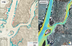
In lower Manhattan, land was reclaimed from the river by filling wetland with garbage and concrete. Governor’s Island grew the same way.

The Hudson River that explorer Henry Hudson sailed some 400 years ago had no power plants on its shores. No trains, bridges, factories or houses. Those innovations changed the river, leaving a legacy of PCBs, sewage and other pollutants. But pollution is just one way that humans have transformed the river. A small way, it turns out.

Humans have altered the Hudson’s shape, the speed of its flow and the mix of plants and trees along its banks. In a new book, Environmental History of the Hudson River, two Lamont-Doherty scientists who contributed chapters—Frank Nitsche and Dorothy Peteet—show what the river looked like before Europeans got here.

In its natural state, the Hudson was wider than today, interspersed with islands. Marshes ran along both shores, giving way to tall forests of chestnut, oak and birch. European settlers soon cleared the forests for farms, and with industrialization, ships plied the river’s waters with people and goods headed upstate and for the Great Lakes. To accommodate the ships, the river was deepened. Wetlands were filled to create ports and meandering side-channels were closed.

Nitsche HumanEffectsHudsonRiver talk 2 300x221.png
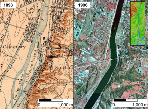
Historic maps show how the Hudson River has grown narrower and straighter, with more rigidly defined shores. Near Troy, NY, several prominent islands have disappeared.

As the river grew narrower and straighter, it flowed faster—speeding up erosion. Between Albany and Troy, much of the fine-grain sediment on the bottom has been swept away, replaced by gravel, says Nitsche, a geophysicist who with colleagues mapped the riverbed from New York Harbor to Troy in the early 1990s.

Rivers naturally flush sediment and nutrients downstream, but as the population along the Hudson grew, so did sedimentation. Deforestation contributed to the process, and so did human waste. In the 1960s, as much as a third of the 1 million metric tons of sediment flowing downstream was made up of sewage. The load fell sharply after the 1972 Clean Water Act, dropping to 52,000 tons by the 1980s. Off-setting some of the sedimentation is another human influence: Some 2,000 dams in the Hudson watershed block sediment flow downstream.

Iona Marsh Peteet2 193x300.jpg
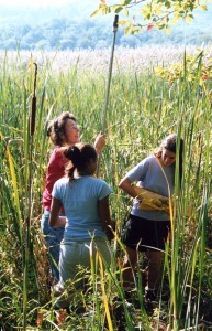
In marshes along the Hudson, Peteet (left) and her students have collected mud samples that reveal changes in vegetation and climate going back hundreds of years.

In the marshes still left, Peteet and colleagues have tunneled into Hudson River mud looking for pollen, seeds and plankton to find out what the ecosystem looked like. Peteet, a botanist and climate scientist, has found that at about 400 years ago, native sedges and saltwater grasses gave way to cattails and common reeds, including the well-known Phragmites. The hardwood trees disappeared as farming developed; some grew back as factories replaced agriculture, except for the American chestnut, which was wiped out in the 1900s by an invasive fungus.

Four hundred years from today, what will the river look like? Sea levels will be higher, and depending on how New York City prepares for the rising waters, the coastline could significantly change. “That’s the biggest effect, I think,” said Nitsche. “I don’t think humans will do much more harm to the river. Maybe we’ll clean it up and restore it. That’s my optimistic view.”