Head for the Hills
While we spent much of our time examining corals and swamps, studying sea level and storms, we became fascinated by a simple question: How did the hills of Exuma form?

By Frank Pavia
After returning to New York from Camp Gumper, I can’t help but reflect on the exploration that I and the other graduate students on the trip undertook. Previous blog posts (here and here) have focused on the specific goals and aims of our expedition, including paleotempestology and sea-level changes. But the trip also forced the students to ponder much broader questions about science itself.
My love of geochemistry and earth science sprouted as I became fascinated by a way of thinking. Geochemistry requires the belief in the mind-boggling idea that the dynamics of the entire Earth can be deduced by measuring atoms. The final goal is almost always to learn about something visible—the ocean, the atmosphere or the solid earth. But the methods require trust in invisible principles—the thermodynamics, mechanics and kinetics of atoms and molecules that cannot be directly seen.
As an earth scientist, I find it surprisingly easy to forget what exactly the Earth is. In the lab, I have to be hyper-focused on not contaminating my samples and making sure instruments are working properly in order to trust that the amount of invisible isotopes I measure are indeed correct. Interpreting data forces me to reduce the Earth to a chemical system. On the bus from the Lamont-Doherty Earth Observatory back to New York City, I see carbon isotopes instead of trees, hydrogen and oxygen isotopes instead of the Hudson River, or thorium isotopes instead of sediment.
Fieldwork inevitably forces me to set a scientific reset button. Scientists are explorers of the invisible, but the implications of their findings on the visible world are what drive them to continue our work. In seminars leading up to our trip, we had learned about storms in the Bahamas and sea-level change, but focused little on the local and regional geology.
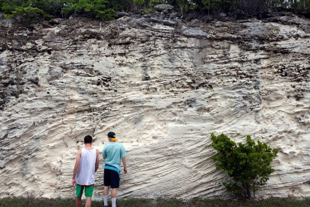
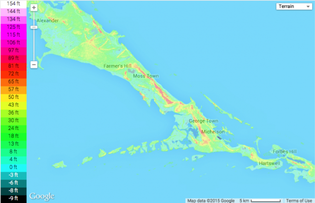
While we spent much of our time examining corals and swamps, studying sea level and storms, we became fascinated by a simple question: How did the hills of Exuma form? Storm deposits and sea-level shifts were massively important for forming the local geology, and we wanted to see if the island dunes might provide insight into both of them. Our conversations, whether during breakfast or 2 a.m. jam sessions, inevitably marched back to this single question.

We went out to the field to try and figure it out. We ultimately narrowed the possibility down to two hypotheses. First, the dunes were transgressive, and formed as sea-level rose. In this case, the dunes would have been formed during the past 10,000 years following the end of the Last Glacial Maximum. Second, the dunes were regressive, and formed as sea-level retreated during the initiation of an ice age. This would lead to a dune age of about 130,000 years, corresponding to the last interglacial. We drew endless diagrams and scenarios trying to figure out which was more likely. We would later find out that the scientific literature had decided that the dunes were likely transgressive, but our own organic research led some of us to believe the dunes were probably regressive. The result was inconclusive.
Here we were, in the midst of a field trip, doing science that none of us typically did. Not a single student on the trip was a sedimentary geologist, yet we became mesmerized by it as we stared at the landscape. Without a lab or instruments, we were forced to answer a visible question using only what we could see. Indeed, sedimentary geology is based on a fundamentally visible principle, uniformitarianism, which states that sediments preserved in the geologic record were deposited the same ways they are in the present.
We all returned to our graduate student lives with a far greater connection to the real Earth. As an oceanographer, I found it critical to interact with the ocean again, to see the reefs and plankton and fish that flourish there. The trip made it possible for us to go back to our studies with a far stronger sense of the physical manifestation of the invisible things we research. We got to recalibrate why the science we do is important.
There are limits to what both the visible and invisible can teach us. Delving further into the invisible allows us to prove more concretely that we interpret our sights correctly. Reducing the Earth to a chemical system limits our ability to connect our measurements to the real world. Just before our flight home, a few of us went back to an exposed rock face to see if we could get a final answer as to whether the Bahamian dunes were transgressive or regressive. We found that the visual could only get us so far. So we got out a hammer, a notebook, and some plastic bags. We took home samples to do some chemistry, too.
Frank Pavia is among a group of nine students from the Department of Earth and Environmental Sciences at Columbia University who spent a week in Exuma, The Bahamas, looking for evidence of past hurricanes. The work is supported by the Extreme Weather and Climate Initiative, Lamont supporter Frank Gumper and other sources.
