Only 270 Million Square Kilometers to Go: The R/V Marcus G. Langseth Maps the World's Oceans
For the first time in almost nine years, the R/V Marcus G. Langseth is back in New York City, stationed at the Brooklyn Navy Yard for some much-needed TLC. State of the Planet got a tour of this impressive seismic vessel, learning how it can help researchers forecast earthquakes and save lives in the process.
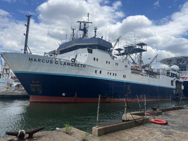
Climbing aboard the R/V Marcus G. Langseth, the first thing you notice is its complexity. There’s a lot going on here, with urgent-looking machinery—tubes darting this way and that, enormous reels of cables, cranes, and even a creaky, uneven gangplank that threatens to topple visitors into the East River. It quickly becomes clear this is no pleasure craft: the Langseth, outfitted with myriad instruments and technology to map the sub-seabed, among other tasks, is a working ship, with the infrastructure and battle scars to match.
The Langseth was originally built as a commercial seismic vessel, used to find oil reserves below the sea floor, but when the Lamont-Doherty Earth Observatory acquired it in 2004, its duties were expanded to that of a general-purpose research vessel. It’s currently one of just five global class vessels—research vessels capable of long-duration missions in extreme environments, i.e., pretty much any part of Earth’s oceans save areas covered by ice—and serves as the national marine seismic facility in the U.S.
Before docking in Brooklyn, the Langseth worked on projects off the west coast of Africa, including South Africa and Namibia. On its month-long transit to New York from South Africa, the Langseth mapped more than 150,000 square kilometers of ocean floor that had never been mapped before.
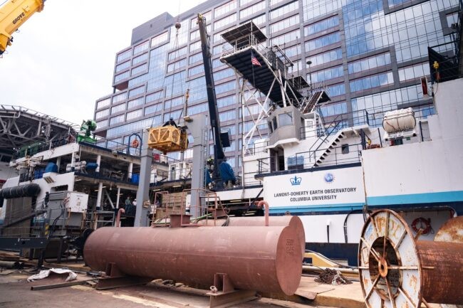
For the first time in almost nine years, after spending 290 days in service this past year, the Langseth is back in New York City, stationed at the Brooklyn Navy Yard for some much-needed TLC. “We’re reconfiguring the ship for the next trip and doing maintenance: Repairing one of the clutches and a turbo charger, and fixing a variety of pipes,” says our guide, Sean Higgins. “We’re packing a lot into a two-week period” before the Langseth sets sail toward Iceland, to track deep-water circulation in the North Atlantic.
Higgins is director of marine operations at Lamont-Doherty Earth Observatory, which is part of the Columbia Climate School. He’s been managing operations aboard the Langseth for the past 14 years. Since 2008, when the ship conducted its first operation to document the sub-seafloor—producing 2-D and 3-D images of the Earth’s crust at the bottom of the ocean—the Langseth has crisscrossed the seas, gathering data to try and forecast seismic incidents like 2011’s Tohoku earthquake, which triggered a tsunami and the resulting Fukushima nuclear disaster.
While no technology exists to prevent such catastrophic acts of nature from happening, by better understanding sub-seafloor topography, where tectonic plates pull and push at each other like wayward siblings, scientists are piecing together ways to forecast seismic events that give residents time to prepare and/or evacuate, should the Big One be in the offing. To that end, in 2021, the Langseth spent almost six weeks mapping the Cascadia subduction zone, which in 1700 produced a magnitude 9 earthquake, but has been suspiciously quiet ever since.
Using Sound to “See” Inside the Earth
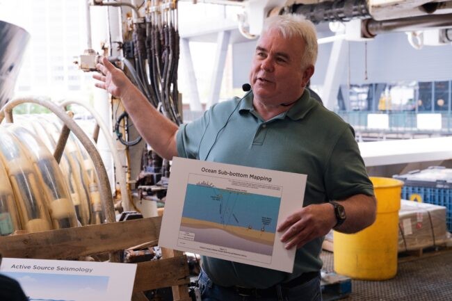
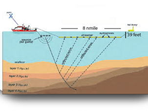
From the deck, we walk to the main lab, which reveal a display of 50 or so computer monitors and other instruments. “We launch the sound source from the main deck,” Higgins says. “It’s basically a tuned set of air guns that use high-pressure air to create acoustic waves. The waves go down to the seafloor, bounce back and are captured by the hydrophones.” The air guns differ in size and scale and thus produce sounds of varying frequency—much like an orchestra, says Higgins. Extraneous sounds are tuned in such a way that they cancel each other out, while the low frequencies continue their journey. “These very low-tuned frequencies of long wavelength can penetrate down through the seabed, and then bounce back from the sub-seafloor to the hydrophones.” Computers absorb this data and generate highly detailed maps of the sub-seafloor. Astonishingly, this system can produce maps of the earth’s crust as deep as 15 to 20 miles below the surface of the seafloor. (For context, the deepest point in the ocean, the Mariana Trench, is about seven miles below the water’s surface.)
Despite worldwide mapping efforts that began in earnest in the 1950s, to date, “Only 20–25 percent of the world’s oceans have been mapped at a high resolution,” Higgins says. “Otherwise, we’re still inferring from satellites and altimeter readings,” which are much less accurate than what a properly kitted out vessel can ascertain with modern bathymetry mapping systems.
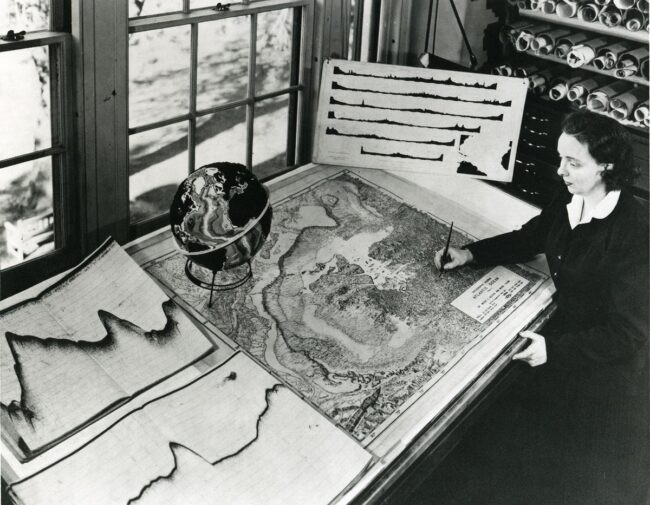
The Langseth is one of five ships operated by Lamont over the past 70-plus years. The seabed-mapping technology has evolved and improved with each vessel. The first such ship was the Vema—which started life as a luxurious schooner built for American finance mogul E.F. Hutton—and was purchased by Lamont in 1953. The Vema’s research contributed to Marie Tharp’s vindication of the theory of plate tectonics. After the Vema (in service from 1953 to 1981) came the Conrad (in service from 1962 to 1989), the Eltanin (1962 to 1975), the Ewing (1988 to 2005), and finally the Langseth, the most technologically advanced of the bunch.
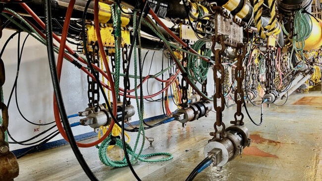
From the lab we walk to the compressor room, where Higgins shows us the massive compressors—some of the largest ever built for seismic work, says Higgins. They are run by two giant yellow steampunk-like Caterpillar diesel engines that were built in the early ’90s. The engines power the compressors, which put out 2,800 cubic feet per minute of highly compressed air that’s tuned in to about 2000 PSI, Higgins says, “and we’re shooting that sound source about every 15 seconds.”
Environmental activists have protested this kind of deep sonic exploration, which can adversely impact marine mammals, notably whales. So to account for any marine-life disturbance, each seismic project has to be vetted well in advance, and Lamont must submit environmental assessments to NOAA National Marine Fisheries Services for evaluation of the project’s potential environmental impacts. Once a project has been approved, the Langseth must also employ, typically, five mammal observers (or protected species observers) on every seismic expedition it undertakes.
But seismic research is but one function of this ship. The Langseth also supports other projects such as oceanographic water sampling and collecting sediment cores. The Lamont-Doherty Core Repository is one of the world’s largest and most geographically diverse, housing over 20,000 marine sediment and rock samples collected from around the globe. The ship also carries instruments that measure how much CO2 is being absorbed by the ocean, which varies but adds up to roughly half the CO2 that humans put into the atmosphere—critical research in helping to slow climate change.
Off the Clock
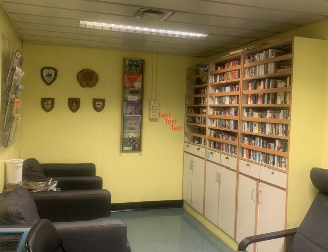
Operations on the Langseth are 24 hours-a-day, seven-days-a-week, but human nature requires a little R&R. Higgins walks us to the dining area, which looks much like your basic school cafeteria, and then to the sleeping quarters, which are modest at best. The ship boasts its own theater room and library, where staff can watch movies and read books to wind down. Many people bring their musical instruments on board, and lab tables get repurposed for ping-pong, Higgins says.
While the Langseth was one of the first ships in the ’90s to start doing multistreamer research, technology marches on, and it’s almost time for a new vessel to take over its duties. But financing a multimillion-dollar ship in an era of budget cuts—to the National Oceanic Atmospheric Administration and the National Science Foundation—is not an easy task. But it’s essential, as marine information accumulated just over the past few decades has turned our knowledge of geology on its head. “The information we’re collecting shows we’re actively discovering the planet we live on,” says Higgins. “There’s still so much uncertainty. It’s amazing what we learn every time we go out on just a single cruise.”
In service of that research, as part of a STEMSEAS program run by Lamont, the Langseth has brought many students out to sea, including those who wouldn’t otherwise have exposure to maritime research, especially students from underprivileged backgrounds. Many have taken a trip and switched majors from non-STEM to STEM, Higgins says.
“The Langseth is an amazing facility, and I’m always excited to show people around,” Higgins adds. “But it raises the question: How do we get to the importance of this ship and what it can do? And how does that relate to education, engineering, technology, leadership and ocean science?” It might not be a stretch to say that its mission, and the mission of similar vessels, is tied to the well-being of billions of people. “We need to convey to the public how important is it for us to be doing this,” says Higgins, “and how what we’ve accomplished over the last 70 years has clearly shown what we need to do in the future.”