Why I Care About the Bottom of the Ocean

It is the middle of the night and I am wide awake thinking about the ocean, specifically the bottom of the ocean. Is it rocky? Jumbled? Smooth? Rocky is bad. Jumbled is bad. Smooth is good.

By
Pratigya Polissar
April 30, 2012
R/V Marcus G. Langseth docked in Honolulu, HI
R/V Marcus G. Langseth docked in Honolulu, Hawaii.It is the middle of the night and I am wide awake thinking about the ocean, specifically the bottom of the ocean.  Is it rocky? Jumbled?  Smooth?  I am wondering this because I want to take samples of the seafloor to study.  Rocky is bad.  Jumbled is bad.  Smooth is good.In one of my favorite New Yorker cartoons a woman says, “I don’t know why I don’t care about the bottom of the ocean, but I don’t.”  Well, for the next four weeks our research group will care a lot about the bottom of the ocean.  We are sailing to the middle of the Pacific Ocean where we hope to collect sediment to study how climate has changed in the past.  Our destination is a group of atolls and seamounts collectively known as the Line Islands.  They include Kingman Reef (U.S.A.), Palmyra Atoll (U.S.A.) and part of the island nation of Kiribati.The ocean around the Line Islands is over two and a half miles deep (4 km)—too deep to preserve the climate changes we want to study.  So, we are going to take sediment cores on the flanks of the islands where the sediments are better preserved.  The flanks are also where a lot can happen to the sediments.  Slumps can break off huge chunks of sediment, ocean currents can erode the sediment and slumps from higher up the flank can deposit thick layers of sediment.  All of these happenings alter or erase the regular ordering of the sediment (the stratigraphy in geologists terms) and make them unusable for our research.  So, I am thinking about the bottom of the ocean.
MGL1208 map blog overview.eps 1 274x600.png
Map showing the first part of our cruise aboard the Langseth. The shaded colors show the depth of the ocean (bathymetry) in meters. The red line shows where we will be heading in the next few days.

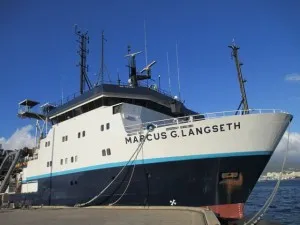
Our group is sailing on the research vessel (R/V) Marcus G. Langseth, an oceanographic research vessel operated by Lamont-Doherty Earth Observatory (where I work).  The ship is a floating scientific laboratory, with the ability to study and take samples of the ocean water and sediments wherever we go.  The scientists on board include seventeen researchers from nine institutions.  In addition, there are 34 technicians and sailors who make sure the ship and scientific instruments are functioning properly so we can collect the data we need.  The moment we leave the dock in Hawaii will be the culmination of almost a year of planning, a lot of hard work by the crew of the Langseth, and financial support from the U.S. National Science Foundation.

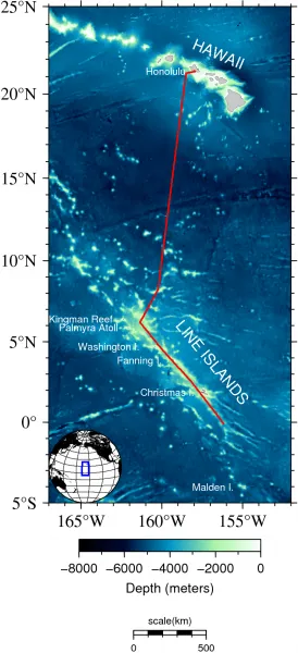
Our goal for this cruise is to collect cores of deep ocean sediment that we can use to study the past behavior of El Niño as well as the climate of the tropical Pacific Ocean.  Although our studies focus on the Pacific Ocean, the results could tell us about many different areas of the globe. El Niño weather affects regions as far apart as Indonesia and New York State.  In fact, El Niño events are responsible for the largest year-to-year changes in global weather.  Our goal is to learn how El Niño has varied in the past so that we can develop better forecasts for the future of El Niño into the 21st century and beyond.

Over the next four weeks I will be writing a series of articles about our cruise.  Topics will include El Niño, life aboard the ship and how we actually collect water and sediment samples from the ocean. Stay tuned!

In the meantime you can track where we are online.