What can we learn from ‘land terminating’ glaciers?
Nature is keeping us in check at every turn. With weather and volcanic ash clouds limiting visibility we have to regularly rearrange plans, but most days we are able to capture a fairly complete set of data.The flight over Russell Glacier in Southwest Greenland (just inland from Kanger) was a redirect from a mission aborted… read more
Nature is keeping us in check at every turn. With weather and volcanic ash clouds limiting visibility we have to regularly rearrange plans, but most days we are able to capture a fairly complete set of data.The flight over Russell Glacier in Southwest Greenland (just inland from Kanger) was a redirect from a mission aborted by ash.
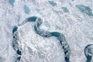
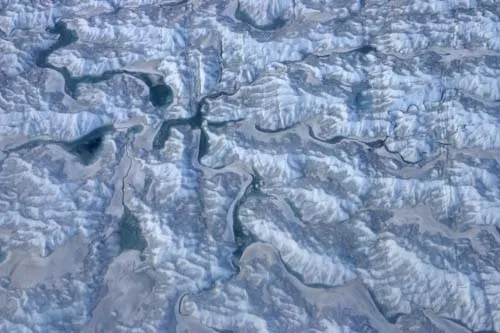
Russell Glacier is unlike most of the glaciers we have been surveying – it is land terminating. Glaciers that end inland raise a whole different array of questions than outlet glaciers that end in the ocean. For land terminating glaciers the major mechanism for melting and losing mass is through surface melt ponds (called supraglacial lakes), and we saw lots of them! Flying at ~1500 feet above land, large volumes of water flowed in an extensive network of lakes and channels, draining the water to the glacial margins as well as into moulins (tubular chutes). The water (lakes and channels) appeared to follow the preexisting surface morphology, which created quite interesting visual patterns as evident in the photos.
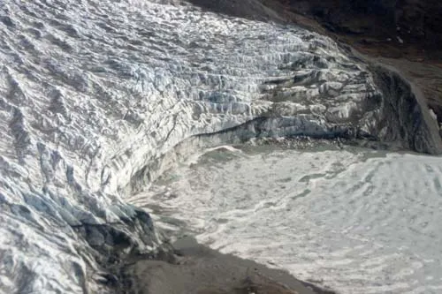
Climate scientists are particularly interested in Russell glacier because they want to determine if land terminating glaciers in Greenland are acting differently than calving outlet glaciers. Outlet glaciers mainly lose mass through calving off chunks at the glacial front which fall into the surrounding water. Unlike outlet glaciers, land terminating glaciers are not affected by warming ocean water or calving. Are both types of glaciers losing mass at a comparable rate? This is a question that IceBridge data hopes to answer.
A large grid was flown on this glacier but unfortunately the grid at higher elevation could not be completed because of the volcanic ash. Changes in each section of the glacier are important, with data from the higher elevation used to constrain the glacier. It is unfortunate that we could not collect the full dataset as there is so much going on higher up that cannot simply be constrained by data at lower elevations. In truth it is often difficult to collect data higher up, as the smaller planes used in flying the outlet glaciers are often unable to fly that high. The P3 was a great solution, and would have been able to deal with the height, but in this flight we were confounded by the volcanic ash!!