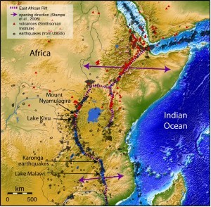
Africa is ripping apart along a 4,000 kilometer seam called the East Africa Rift, which stretches from the Red Sea to Mozambique. This huge continental tear started in the north about 25 million years ago and has been gradually unzipping to the south, with rifting in Malawi starting about 10 million years ago. Breaking up a continent is no easy task, so things are going very slowly. The rift in Malawi is opening at less than 3 millimeters per year. Your fingernails grow faster.
Nonetheless, very slow movements over long periods of time produce dramatic results. Rifting in Africa has created huge depressions that are now filled by some of the largest and deepest lakes in the world, including Lake Malawi, at 335 miles long and up to 2600 ft deep. The lake is flanked by sharp peaks that loom 6,500 ft above the water.
These mountains are the surface expression of massive faults that continue deep into the earth. Sudden movements on these faults regularly produce earthquakes along the entire East Africa Rift. Most are small, but large earthquakes capable of serious damage sometimes occur, as Malawi saw in December 2009. Earthquakes as large as 7.0 have struck in the past. The rift is studded with active volcanoes that pose a risk to nearby cities and villages. Right now, 650 kilometers north of the earthquakes in Karonga, Mount Nyamulagira is erupting. The volcano is only 20 miles from the northern shore of Lake Kivu, where the combined population of the cities of Goma in the Democratic Republic of Congo and Gisenyi in Rwanda is close to 500,000.

