Upcoming Scientific Fieldwork: 2017 and Beyond
On every continent and ocean, Earth Institute field researchers are studying the dynamics of climate, geology, natural hazards, ecology and other subjects with direct applications to the challenges facing humanity.
March 06, 2017
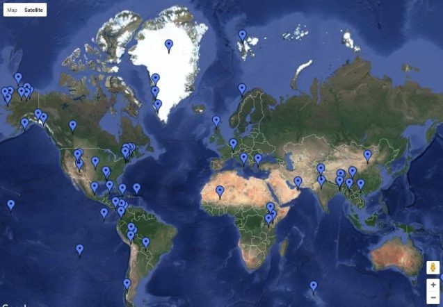
Click on the image to see a map detailing Earth Institute fieldwork.[Last updated Nov. 8, 2017]On every continent and every ocean, Earth Institute researchers are studying climate, geology, natural hazards, ecology and more. Below, a list of projects in rough chronological order. When logistically feasible, journalists are encouraged to cover expeditions. Work in the U.S. Northeast is listed separately toward bottom. Unless otherwise stated, projects originate with our Lamont-Doherty Earth Observatory. We will make video and still images from the field available whenever possible. More information: Senior science editor Kevin Krajick [email protected], 212-854-9729. U.S. AND INTERNATIONALTESTING SOUTHERN WINDS Bog coring, New Zealand LATE MARCH 2017Warming climate has caused dramatic rainfall decreases on New Zealand’s South Island; storm tracks have been pushed far southward into the Southern Ocean, decreasing rain as much as 40 percent in the last 30 years. This is of concern not only to New Zealanders, but lands in the same latitude as far east as Chile. In order to understand how far this trend may extend, paleoclimate researcher Jonathan Nichols and colleagues will take cores of peat from an ancient bog at Letham Burn, an uninhabited area in the southwest corner of the island. Here, the remains of plants have been building for many thousands of years, leaving behind chemical isotopes that the researchers believe will indicate levels of rainfall during past, comparable warm periods. Smithsonian article on Nichols’ bog workDEEP-EARTH DESERT Drilling, geologic fieldwork, Oman JAN-APRIL 2017, and NOV 2017-FEB 2018In the desert nation of Oman, rocks from earth’s mantle, usually inaccessible to humans, have been thrust to the surface in the mountainous Samail Ophiolite. The rocks have many unusual qualities, including the ability to naturally take up vast amounts of atmospheric carbon and convert it to solid carbonate. In the first project of its kind, an international team is taking deep cores and performing experiments in the formation. The project should yield insights into physical and biological processes in the deep earth; it could also show the way to harness natural underground processes that could suck vast amounts of excess globe-warming carbon from the air. Geochemists Peter Kelemen and Juerg Matter are leading about 40 other researchers from some half-dozen nations. Four holes of some 1,200 feet are now being drilled in the Wadi Tayin massif, where rocks have been converted almost entirely into carbonates. Next winter and spring, the team will penetrate zones where carbonation is still ongoing. Video, photo essay, story on the project / Oman Drilling Project webpages / Scientific Drilling to Throw Light on Oceanic PlatesICE-AGE SCOTLAND Sampling of glacial debris MARCH 2017Some 12,000 years ago, much of the northern hemisphere, including Scotland, went back into a mini-ice age after several millennia of warming, and glaciers re-advanced. The ice then remelted, leaving debris that we can see today. Glacial geologist Aaron Putnam and his colleague Gordon Bromley of the University of Maine are investigating the timing and causes of this event by sampling boulders once covered by ice, and organic matter preserved in ancient bogs that directly overlie glacial till. Their next research trip is tentatively scheduled for March.CLIMATE AND CONSERVATION Planning for agriculture and land protection, Myanmar, Paraguay, Mexico, Belize, Guatemala, Colombia, Bhutan MARCH/APRIL 2017 and ONGOINGThe World Wildlife Fund and the Center for Climate Systems Research are collaborating to integrate climate projections into land-use planning across the world. In Myanmar, a team led by Radley Horton has developed climate-risk information for the whole country, and is working with the UN in two vulnerable townships, one in a dry zone, the other in the wetter delta region. They will present results March 23-26 at Myanmar’s first film festival. In Paraguay, an initial workshop and field trip aimed at bolstering farming resilience and forest conservation is planned for March or April. Other upcoming projects to start in 2017 include an assessment of risks to reefs off Mexico/Guatemala/Belize; a forest conservation initiative in Bhutan; and assessment for mangrove protection on the Pacific coast of Colombia. Article on the project GREAT PLAINS DROUGHT Fine-scale ground measurements, Oklahoma, MARCH-MAY 2017Led by Pierre Gentine of the Columbia Water Center, researchers will look at how temperature, air turbulence and moisture interact along the land surface to produce evaporation and drought. They will use fiber-optic cables and lasers to make fine-scale measurements—a sample every second, every 10 centimeters—along a mile-long cable stretched across agricultural land. The results will help fine-tune hydrologic and climate models, enabling better predictions of drought. Story on Gentine’s U.S. grasslands workVIKING TIMES Lake coring, archaeological work, Lofoten Islands, northern Norway MAY 10-20, 2017Paleoclimate scientists William D’Andrea and Nicholas Balascio will look into natural factors that may have influenced the growth of northern agriculture and rise of violent Viking chieftains during the Iron Age, ca. 500 BC to 1100 AD. The arctic Lofoten Islands were marginal for farming, so inhabitants were probably susceptible to small temperature swings, as well changes in sea level (2 to 3 meters higher in the Iron Age than today). Here, powerful Viking rulers and their predecessors left behind hundreds of dwellings, boathouses and other structures. How did they influence the land, and vice versa, as Viking culture took hold? Why did Viking chiefdoms collapse? D’Andrea and Balascio will take cores from the bottoms of deep lakes surrounding one major chieftain’s domain, and analyze them for changes in vegetation, livestock and use of fire that might help with such questions. The team will also mine extensive untapped Norwegian archaeological archives from digs dating to the 1980s, and synthesize the information with the climate data. Story, video, slideshow on the projectDEADLY DRINKING WELLS Geology/agriculture research, India MARCH 20-28; Bangladesh MAY 1-15; Vietnam SEPT 4-8, 2017 and NOV 2017; China OCT 2017Naturally occurring arsenic is a major problem in wells across southeast Asia, and despite mitigation efforts since the 1990s, many people are still exposed. Geochemist Alexander van Geen and colleagues have studied the causes and possible mitigation measures for years. In March, they will conduct drilling in India’s northern Punjab province to assess not only arsenic, but apparent naturally occurring high levels of fluoride. In May, they will visit farmers in Bangladesh to assess the effects of arsenic-laced water on rice yields, and field experiments to replace arsenic-laden soil. In September, van Geen and geochemist Ben Bostick will conduct drilling near Hanoi, to study how massive groundwater pumping is pulling arsenic plumes ever closer to the city water supply; this trip is conjunction with colleagues from Massachusetts Institute of Technology. Videos and story on Asian geological and health studies / Arsenic pollution near Hanoi / U.S. wells tainted by arsenicCLIMATE AND THE FATE OF NORTHERN WILDLIFE Tagging migratory birds, northern Alberta MID-APRIL 2017, continuing 2018North America’s boreal forests are warming fast, with major effects on trees, but little is known about effects on wildlife. A consortium of U.S. and Canadian researchers has started a 10-year campaign to put satellite trackers on animals including eagles, caribou, wolves and bears, and observe their behavior in relation to new trends in fires, insect populations and water availability. Ecologist Natalie Boelman is studying the common American robin, which appears to range as far as northern Alaska. In April, a grad student will head to Slave Lake in northern Alberta to tag three dozen robins. Courtesy of a new app, the researchers, and elementary-school students, can watch in near real time where they go. Expedition Blog / Overall project website / Animals on the Move / Boelman’s tundra ecology work in Alaska / NASA project blogWATERY GREENLAND Snow drilling, southwest Greenland APRIL 18-MAY 20, 2017, continuing 2018-19Recent surface melting of Greenland’s ice sheet has accelerated so fast, liquid runoff—not the calving of icebergs—has become the primary source of sea-level rise coming from Greenland. Previous research suggested that water normally percolates through subsurface snow and stays there as liquid over multiple seasons. But newer findings suggest that water may now be refreezing near the surface, forming a massive impermeable cap that will hasten runoff to the sea in coming warm seasons. To study this critical zone, a team including glaciologists Jonathan Kingslake and Marco Tedesco will participate in a 150-kilometer trek by snow machine to drill four 75-foot-deep holes into the snow and firn (compacted snow). They will perform detailed analyses on the cores, and leave instruments in the holes to monitor conditions, to be retrieved in 2019. In concert with Rutgers University, University of Alaska Fairbanks and colleagues from France, Germany and the UK. Recent study on subsurface Greenland meltwater / The Great Greenland Meltdown COFFEE AND CLIMATE Workshops with farmers, Jamaica APRIL-JUNE 2017Researchers at the International Research Institute for Climate and Society will visit communities in the Blue Mountains of Jamaica to introduce coffee farmers to newly available climate information, and how it may be used to make planting decisions. The workshops are part of a long-term project aimed at giving Caribbean farmers access to medium-term (3 months out) forecasts that can help them cope with droughts, floods and other extreme weather. Done in conjunction with the University of Arizona; IRI lead on the project is Ashley Curtis. Background on the project | Story about the project’s progress MIXING OIL AND WATER Study of a natural hydrocarbon seep, Gulf of Mexico MID-MAY, LATE JUNE, LATE SEPT 2017The seafloor of the oil-rich Gulf of Mexico contains many natural features where hydrocarbons seep naturally into the water from the seabed. In the wake of the catastrophic 2010 Deepwater Horizon oil spill, researchers have been intensively studying seeps to better understand how hydrocarbons move and interact with water. This year, a team including oceanographer Andreas Thurnherr will conduct three short cruises to place and recover acoustic instruments that will measure the dispersion of hydrocarbons from one seep in the northern Gulf. Each cruise will last two to three days. Related research on oil seepsTUNDRA ON FIRE Lake coring, vegetation studies, northern Alaska, APRIL and AUG 2017; continuing 2018On the northern tundra, once-rare wildfires sparked by lightning appear to be multiplying in response to hotter, drier summers. A team including paleoclimatologist Benjamin Gaglioti is investigating the frequency of such fires and their effects on vegetation and underlying permafrost. In April they will travel by snow machine to remote camps on Alaska’s North Slope to core lake sediments thought to preserve signs of past and recent fires that can be compared. Sites include the Lake of the Pleistocene and Perch Lake, in the foothills of the Brooks Range. In August, they will travel to study widespread sites of old burns, and how fires may have affected the underlying ground and ecology. Fieldwork in 2018 will include a 500-kilometer overland journey to study the effects of more recent fires.A GHOST FOREST REVEALED Tree ring collection, La Perouse Glacier, southeastern Alaska MAY 2017In June 2016, researchers including paleoclimatologist Benjamin Gaglioti and a colleague from the University of Alaska discovered several long-buried forests that had been newly revealed along the retreating margins of the La Perouse Glacier in southeast Alaska. Many of the trees, estimated to have been covered up 450 to 1,650 years ago, are still standing upright. The scientists will return in May to sample rings from them. These will provide information about how both glaciers and trees have responded to naturally shifting climates of the past, and inform projections into the future. The project is urgent, as the newly exposed trees are already starting to decay, and outwash of sediment from the glacier could rebury them at any time. The team will land by bush plane and camp on a beach in a remote area situated within Glacier Bay National Park.HOW DO FORESTS REGROW? Tree studies, Puerto Rico APRIL 1-14 and MAY 2017, JANUARY 2018At least half the world’s tropical and subtropical forests are products of recent human disturbance—regrown after farming, logging or fires. Puerto Rico. for instance, was almost completely deforested 50 years ago, but is now again 60 percent trees. Forest ecologist Maria Uriarte is working in the mountainous Luquillo Experimental Forest to understand how second-growth dynamics may differ from those more commonly studied virgin forests, and the implications for biodiversity, water resources and climate. Uriarte is documenting which species take hold, how fast they grow, and how they react to changing weather—all factors that may affect carbon uptake, and play into future global climate models. In a related project, in January 2018, Uriarte and colleagues will work at the forest’s upper reaches to study how the remnants of a long-disappeared ancient shoreline now high up on the slopes may be influencing growth. Uriarte research pages / Luquillo Long Term Ecological ResearchCAN GOLD MINING AND NATURE COEXIST? Conflict resolution, Peruvian Amazon, LATE MAY/EARLY JUNE 2017The Madre de Dios region of the Peruvian Amazon is rich in biodiversity, and is technically under government protection. In reality, miners have flooded in to sift abundant gold from its riverbeds, leading to armed confrontations with the Peruvian military. The Advanced Consortium on Cooperation, Conflict and Complexity (AC4) is working in partnership with residents, NGOs and government officials to test techniques to peacefully reconcile resource management with biodiversity. To move the project forward, a team led by AC4 director Joshua Fisher will visit the region in the last week of May and first week of June 2017. New York Times feature on Madre de DiosBETTER FERTILITY FOR AFRICA Soil analyses, Mali and Tanzania SPRING 2017 The Agriculture and Food Security Center is using SoilDoc—a portable, real-time soil-testing kit that provides small farmers with crop and fertilizer recommendations across Africa. In May, postdoc Christine Sprunger will study soils across Tanzania, in fields that have already been assessed, and where potential improvements were implemented. Led by Chris Lambe and Kevin Tschirhart, the project is also expanding to Mali in spring 2017. Video on SoilDocTHE THIRD POLE Field geology, tree-ring sampling Bhutan SPRING or FALL 2017Many Bhutanese glaciers are receding, endangering vital water supplies and hydropower facilities for nations downstream; and big meltwater lakes are building behind leaky natural dams that could burst. An interdisciplinary team is working to understand past glacier dynamics, and help predict future behavior. Pending funding in 2017, a team including glacial geologist Joerg Schaefer and grad student Josh Maurer plan to collect rock samples and study landforms in the little-visited eastern Jomolhari region, along the border with Tibet. This will be collated with other data including tree rings taken by Lamont dendrochronologist Edward Cook and colleagues at lower elevations. Cook intends to return to collect more tree rings in October 2017. Anthropologist Benjamin Orlove is studying the human dimensions of glacier retreat, and may return to Bhutan in 2018. New York Times blog from 2012 expedition / Read an article about the projectDARKENING ICE Sampling snow, meltwater, southern Greenland MID JULY 2017Polar scientist Marco Tedesco will join colleagues studying soot and algae building up on the Greenland ice sheet surface and apparently hastening its melting. Tedesco will sample snow and water to refine understanding of how the invaders are darkening the surface, decreasing its ability to reflect sunlight, and thus increasing absorption of solar radiation. The so-called Black and Bloom team includes glaciologists, biochemists and microbiologists. As an offshoot, Tedesco hopes to collect material to develop a virtual reality package that will bring the sights, sounds, and even the smells of the summer Greenland ice to a wide audience. Black and Bloom website / Greenland’s Ice Is Getting DarkerNORTHERN FORESTS AND CLIMATE Tree ring collection, northern Alaska JULY/AUG 2017Researchers Laia Andreu Hayles and Benjamin Gaglioti will fly by bush plane to remote areas in northern Alaska to revisit and sample slow-growing trees first studied by Lamont scientists some 30 years ago. The study is aimed at discovering how trees have fared under warming climate. In some places, forests are thought to be greening and growing faster, while in others, heat-induced stress may cause them to brown and die; local and regional factors are thought to be at play. The work will take place along the Noatak River, near the western coast, and in the jagged granite Arrigetch Peaks region of the Brooks Range. Principal investigator: Rosanne D’Arrigo.EUROPE’S MELTDOWN Studies of glaciers, Swiss Alps SPRING/SUMMER 2017The Rhone River supplies water for France’s hydro dams and coolant for nuclear plants—but Switzerland’s Rhone glacier, the main source of summer flow, is disappearing. Already, lower water and higher water temperatures in warm months have forced nuclear plants to shut at times. By sampling bedrock that contains chemical clues, glacial geologist Joerg Schaefer and grad student Joshua Maurer are evaluating the ice’s past responses to changes in temperature and precipitation. Dependent on funding, they plan to visit the glacier this summer. In a related project, this spring they will sample bedrock underneath the ice at Jungfraujoch, an 11,400-foot saddle near the top of the Swiss alps. An earlier sample from here suggests that the area was ice free some time in the past 12,000 years—a big surprise, and possible evidence that even the higher Alps may be more susceptible to losing ice rapidly than previously thought. Rhone project web pageEARLIEST HUMANITY Archaeological dig, Kenya JULY 10-25, 2017 and ONGOINGThe remote desert region around northwest Kenya’s Lake Turkana is the source of many key early human fossils and artifacts. Paleoclimatologist Kevin Uno will join an excavation team led by archaeologist David Braun of George Washington University to the Koobi Fora formation, on the lake’s east side, where they expect to find abundant stone tools. Uno will help date these by analyzing adjoining plant remains. The dig will be repeated in 2018 and 2019. Lamont-Doherty geologist Christopher Lepre, who also works around Turkana, recently helped a separate team date what are currently the world’s oldest known tools, at 3.3 million years. Lepre uses changes in earth’s magnetic field to date artifacts; he tentatively will return to Turkana this year as well, pending funding. Story/video/photos of Turkana workDE-ICING CENTRAL ASIA Chinese Himalayas, Sichuan Province, SUMMER 2017Much of mountainous central Asia, where glaciers feed water to hundreds of millions of people, is warming faster than the rest of the world. What did it do in the past? Scientists are working to understand the chronology of deglaciation here, to get at the root causes of abrupt climate changes, including any that might be coming up. In Sichuan province, glacial geologist Aaron Putnam will lead an expedition to a splinter range of the Chinese Himalayas, where landforms left by receding glaciers at the end of the last ice age are exceedingly well preserved. He and his team will chisel or blast off samples of boulders dropped by the ice for high-precision dating. By mapping out past positions of glaciers, he and colleagues hope to add to the understanding of how natural changes in earth’s orbit and carbon-dioxide levels influence climate, and what the consequences are. Done in conjunction with Chinese colleagues.SNOWFALL, ABRUPT CHANGE AND THE NORTHERN ICE Sampling lakebeds, rock outcrops, western Greenland JULY-AUG 2017; CONTINUING SUMMER 2018Greenland’s ice is declining, possibly threatening coastal cities with inundation in coming decades. But some scientists argue that the ice sheet may remain fairly stable at least in the short term, because warming could soon produce more snowfall to offset melting. To help resolve this question, a team including polar scientist Nicolás Young is studying how temperature and precipitation have combined to affect the ice over the past 8,000 years. Working by helicopter and camping in the field, they will sample rocks and lakebed sediments around the ice edges, and analyze them for signals of ice advances and retreats. In a related project, Young’s team will also test the competing hypothesis: that the ice could waste abruptly as a result of temperature alone. This idea is supported by glacial geologist Joerg Schaefer, who recently published a study suggesting Greenland was nearly ice free during one or more past warm periods. The team will sample debris that could indicate what the glaciers did during short-term temperature shifts 8,200 and 9,300 years ago, and Schaefer will analyze it using newly available pinpoint methods able to distinguish events during time scales of just decades. Description of precipitation project / Description of abrupt change project / Ice-free Greenland studyASTONISHING DROUGHT IN THE MIDEAST Sediment collection, analysis, Jordan/Israel JUNE 2017A new study of deposits drilled from deep under the bed of the Dead Sea shows that the Mideast has suffered droughts far more drastic than those seen recently, in a trend tied to global warming. Does this mean things could get much worse, much faster than generally believed? A team led by geochemist Yael Kiro will collect salts and other geological materials on land near the Dead Sea similar to those that have washed into its ancient bed; their hope is to refine understanding of where the climate has been, and where it might go. The project is designed to yield practical knowledge for addressing water issues in this already thirsty and violent region, and to encourage cooperation among American, Israeli, Jordanian and Lebanese scientists, who rarely collaborate as a result of the region’s difficult political environment. Work will be based out of the Columbia Global Center in Amman. Deep under the Dead Sea, Warnings of Mideast DroughtCARBON STOREHOUSE Studies of plants, northern Alaska MID- AUG 2017For thousands of years, plants in arctic bogs have soaked up vast amounts of carbon dioxide, storing it in the dead plant matter that makes peat. With warming climate, vegetation types are changing, and some bogs are thawing and releasing their carbon—but it is not clear whether the net effect will be more carbon storage, or less. In a multiyear project out of the North Slope’s Toolik Lake Field Station, paleoclimatologists Jonathan Nichols and Dorothy Peteet are studying both living plants and the remains of their predecessors, and their ability to store carbon. Video on bog projectTREELINE VS. TUNDRA Plant/soil/weather surveys, northern Alaska and Northwest Territories JUNE/JULY 2017, continuing 2018Across the fast-warming arctic and subarctic, tree seedlings now taking root may eventually advance the 13,400-kilometer-long circumpolar treeline into what is now open tundra. This could portend huge changes in far northern ecology, and the carbon budget of the planet. Teams have placed suites of sophisticated instruments to measure physiological processes of trees at the very edge of their range, and are integrating real-time observations on the ground with remote-sensing data to tease out what might happen. Last June, a team including plant physiologist Kevin Griffin and ecologist Natalie Boelman planted instruments in plots along northern Alaska’s Dalton Highway. They will return here in June or July, and/or work at similar sites near Inuvik and Fort McPherson, in Canada’s Northwest Territories. All sites are accessible by road. Story, video and slideshow on the project / Tundra ecology websiteTEAM VOLE Climate-related small mammal studies, northern Alaska, JULY 2017, continuing through 2021Researchers have been studying the effects of warming climate on tundra plants for nearly three decades, but very little is known about how voles and other numerous rodents may react, possibly producing unpredicted changes to the ecology of the tundra. Plant physiologist Kevin Griffin and ecologist Natalie Boelman will study plant-eating rodent populations and their effects on plant communities at plots in the northern foothills of Alaska’s Brooks Range, the southerly Seward Peninsula and the northwestern coastal village of Barrow. The five-year project will include setting up experimental plots to monitor rodent populations in relation to plant growth and composition, and making projections of their interactions over the next 50 to 100 years. Story, video and slideshow on related tree line project / Tundra ecology website**MARS ON EARTH Surveys of stromatolites, Wyoming AUG 2017 [**Postponed to summer 2018]Stromatolites—masses of rock built up in shallow water by ancient photosynthetic bacteria—are among the most visible signs of ancient life. Southern Wyoming’s Green River region has some of the most spectacular formations, rising 30 to 60 feet above the deeply eroded landscape, thought to be 30 million to 50 million years old. Geochemist Sidney Hemming and colleagues will spend two weeks studying the formations to refine understanding of how and when they were laid down. Camped in the field, the team will map strata and take samples for lab analysis. The research may be used as an analog in the search for life in Mars’s Gale Crater, where, if life did exist in the past, the remains might resemble stromatolites. The work may also apply to oil exploration, since stromatolites can produce petroleum when buried below the surface.ARCTIC GLACIER HISTORY Lake coring, Svalbard Archipelago, Norway, LATE AUG-EARLY SEPT 2017With the aim of putting the currently rapid retreat of Arctic glaciers into the context of the last 10,000 years, researchers will travel by ship and foot to collect sediment cores from lakes in the northernmost reaches of Norway’s Svalbard Islands. Minerals in the sediments can tell scientists when glaciers expanded or shrank, and remnants of algae can tell them how temperatures varied. Lamont climate scientist William D’Andrea will join colleagues in this completion of a project started in 2013. The team will probably sail from Longyearbyen, the only real settlement in the mostly barren islands. Story on D’Andrea’s previous work in SvalbardMYSTERY OF THE MOAI Lake coring, Easter Island OCT 2017Easter Island is one of the most isolated places on earth. It was probably not colonized by people until about 1,000 years ago, when a now-lost civilization erected giant stone sculptures, or moai, but then quickly collapsed. Popular theory says the settlers committed “ecocide” through deforestation, introduction of rats, and generally exhausting resources. But paleoclimatologist William D’Andrea believes the evidence is weak, and that climate swings may have played an unsuspected part. He aims to plumb a deep volcanic crater lake for sediment cores spanning some 4,000 years, and analyze them with newly advanced techniques to better understand exactly when people arrived, and what happened to them. The cores should reveal precipitation and fire patterns over millennia and, using new DNA methods, the exact arrival time of humans and livestock. He suspects the results may help rewrite the history of the island, and exhibit a powerful ecological lesson for current times.RISE OF DINOSAURS Geology, fossil hunting, China JULY 2017; Arizona, Utah TBDLamont paleontologist Paul Olsen is studying shifts in the climate some 180 million to 200 million years ago, when dinosaurs rose. In May, he will join an expedition with Chinese colleagues to the Junngar Basin desert in northwest China. Finds made by the team last year suggest that at least some dinosaurs resisted freezing conditions that killed off competitors at one point—a possibility that might change some views of their evolution. In closely related work, Olsen and colleagues will continue investigating rocks from the same time in the region around Arizona’s Petrified Forest National Park, where recent drilling has yielded new data. Olsen plans to scope out two future drilling sites, in the desert near southern Utah’s Zion National Park, and Ward Terrace, on Navajo land in northern Arizona. Tentatively, a workshop to discuss new will be held in Flagstaff, Ariz., in September or October 2017. Story, video and photo gallery on Petrified Forest fieldworkSEA ICE AND NATIVE CULTURE Drone flights, Chukchi Sea, northwest Alaska SEPT/NOV 2017 and SPRING 2018-19In the first project of its kind, geophysicist Chris Zappa and colleagues will study the decline of sea ice in the Chukchi Sea, off northwest Alaska, using drones and traditional knowledge. Working out of the native coastal community of Kotzebue, scientists will collaborate with residents to design research questions and procedures, incorporating local knowledge of water currents, seasonal weather and wildlife. Instrument-equipped drones will record sea-surface temperatures, ice topography and thickness, changes in algae biomass and other qualities. Drones, never used in this setting before, can observe on much finer scales than satellites can. Their combination with indigenous knowledge is expected to open new insights into how climate change is acting upon the northern sea ice, and improve projections for the future. Pilot flights and initial community meetings take place this year; larger campaigns will be carried out in spring 2018 and 2019. Article on the project / Exploring earth in real timeCYCLONE DANGER TO MUMBAI Climate, storm-surge modeling, infrastructure studies OCT 2017-JUNE 2018The coastal megacity of Mumbai has not seen a major tropical cyclone for many decades–and in the meantime has seen destruction of floodplains that previously buffered inland areas, and booming construction to the water’s edge . A team is studying the city’s vulnerability to storm surge, which appears to be very high. Led by Adam Sobel, head of Columbia’s Initiative on Extreme Weather, scientists are modeling the possibilities of large future cyclones, studying the depth and shape of the nearby seafloor, and assessing possible effects on water, sanitation and health. They are factoring in rising sea levels and other dynamics related to climate change. The project is inspired in part by the unprecedented destruction caused by Hurricane Sandy to New York City, whose own history of coastal development greatly resembles that of Mumbai. A postdoc is in Mumbai through next June; Sobel will probably visit in December 2017. Article on the projectSOURCES OF EXPLOSIVE VOLCANISM Lava sampling, Mexico TBD 2018Mexico is strung with potentially explosive volcanoes, but their magma sources are not fully understood. In 2017, geochemist Susanne Straub hopes to continue previous work ascending active high peaks to collect samples of lava and tephra for analysis. At elevations up to 4,400 meters, sites prospectively include Malinche, Pico de Orizaba and Sierra Negra volcanoes. The collections are aimed at testing the idea that the volcanoes are fueled when parts of earth’s crust sink and mix with material from the mantle, further down. This may shed light on how explosive magmas form, move upward, and how long it takes to build to an eruption.WARMING ANDES ECOSYSTEMS Mountain surveys, Colombia, Ecuador, Bolivia, Peru ONGOINGThe paramo regions of the Andes—high elevation ecosystems above treeline, but below the glaciers—harbor unique ecosystems, and provide water to major cities below. But with climate change, clouds are thinning, land drying, and wildfires increasing, stressing plants and other biota. Since 2004, scientists led by Colombia-based Daniel Ruiz Carrascal of the International Research Institute for Climate and Society have worked to understand trends at sites including Los Nevados Natural Park, near Medellin. This year, the team will conduct four or five expeditions to collect records from automatic data loggers along the spine of the Colombian Andes on the El Ruiz-Tolima volcanic massif, a string of high volcanoes. Trips are planned for mid February, late March, early June, late August and early November. Carrascal is also working in the El Angel-El Golondrinas reserve, along the Colombia-Ecuador border; and the Madidi-Apolobomba protected area of Bolivia and Peru. Watch a slideshow on the project / Project blog post / Video on related study of Andean glaciers / Catalog of high Andean floraFARM TO TABLE Research on farmers’ diets, India SPRING/WINTER 2017Small farmers produce 80 percent of food for Asia and sub-Saharan Africa, yet the farmers often lack sufficient nutritious food. Researcher Pinki Mondal of the Center for International Earth Science Information Network and Earth Institute professor Ruth DeFries are leading an interdisciplinary team of geographers, nutritionists and economists to examine the diets of small farmers with a variety of income levels. Collaborating with Indian researchers, they are looking at the accessibility and affordability of nutritious food in rural India. Data collection continues for three seasons (summer, monsoon, winter) over the next year.RESCUING SLAG AND CO2 Steelworks recycling project, northern China 2017/2018China makes half the world’s iron and steel, creating huge amounts of slag and carbon dioxide. Now, researchers from the Lenfest Center for Sustainable Energy are working with a major steelmaker in Inner Mongolia to design and install equipment that will combine the two waste streams into substances going into the paper, plastic, paint, plastic, cement, oil and gas industries. A prototype is already in the lab at Columbia’s New York campus; the scaled-up version is scheduled to be up and in operation by mid-2018. The project to create so-called “green ores” is led by Ah-Hyung (Alissa) Park and Xiaozhou Zhou. Article on the projectEARTHQUAKES IN BANGLADESH AND MYANMAR Geologic mapping, seismometer installations NOV 2017; FEB 2018; SPRING 2018Recent work in densely populated Bangladesh has revealed geologic stresses that could lead to huge earthquakes, tsunamis and sudden shifts in the courses of great rivers. Geologists Leonardo Seeber and Paul Betka are mapping faults, past river-course changes and earthquake potential in adjoining areas of northeast India and western Myanmar; their next trip will be in November 2017. Teams led in part by geophysicist Michael Steckler visit widespread parts of Bangladesh regularly to install and monitor GPS instruments and seismometers; his colleague James Gaherty and other will next go in February 2018. Steckler will work in both Bangladesh and Myanmar in the spring. Watch a documentary about the project / Project blog / Giant Earthquakes Threaten BangladeshICE AND ROCK Geologic fieldwork, Transantarctic Mountains NOV 2017Recently, geophysicists have roughed out maps of Antarctica’s mountains, valleys and plains, but no one has actually seen most of these features; they are 98 percent buried under deep ice. Thus, almost nothing is known about their composition or evolution. To help remedy this, a team including geochemist Sidney Hemming will traverse sections of the Transantarctic Mountains, a 3,500-kilometer range of high peaks sticking above the ice that bisect the continent. The scientists will make measurements and take samples of rocks for comparison with ocean sediments formed along the continent’s edges by erosion from the interior. They hope that analyses will help clarify the erosion history of Antarctica over the last 34 million years. This would in turn shed light on past climates, and how they have affected the ice cover, and enable better projections to be made for the future. Done in conjunction with the University of Arizona.‘BRAZILIAN ATLANTIS’ Sea Bottom studies off Brazil DEC 12, 2017-Feb 6, 2018In 2013, Brazilian scientists found igneous rocks far off the nation’s coast in south Atlantic that some speculated suggested they had found remains of a lost continent. The region contains a large ridge, and many seamounts. The remote area, called the Rio Grande Rise, is barely explored. A multi-institution team aboard the research vessel Atlantis, including geochemist Cornelia Class, will survey the area and dredge samples from the bottom. Class has previously investigated igneous rock in Panama, Tanzania and many other nations . Wikipedia entry on Rio Grande RiseMELTING CONTINENT Physical/biological oceanography, Antarctic Peninsula JAN-FEB 2018For nearly 40 years, scientists have monitored the effects of climate change on the Antarctic Peninsula, one of earth’s fastest-warming regions. As part of a global network of Long Term Ecological Research (LTER) stations, researchers have witnessed a sea-ice season now three months shorter, and dramatic shifts in wildlife populations, including penguins. Hugh Ducklow, a biogeochemist at Lamont-Doherty, is lead investigator of the LTER Project; he and colleagues will spend a month on the icebreaker Nathaniel B. Palmer cruising the peninsula’s west coast to study its creatures and collect physical data. In 2015, the program added a new team, studying Antarctic whales. Story on recent work on the peninsula / Team paper on ecological changesDIAMOND MINES AND CLIMATE CHANGE Carbon sequestration experiments, South Africa, other nations TBD 2018Diamonds are mined from a peculiar type of rock called kimberlite that erupts from about 100 miles under the surface. In addition to hosting gems, kimberlite has another unusual quality: it reacts rapidly with carbon dioxide to form a solid mineral. With the help of geochemist Peter Kelemen and others, the DeBeers diamond company is working on ways to absorb large amounts of carbon dioxide into tailings at several of its mines in South Africa and northern Canada. The idea is to speed up natural processes to absorb carbon dioxide produced by mining machinery and maybe directly from the air itself. Methods could be applied to rock mined for other commodities, including nickel and platinum. Kelemen may travel to South Africa in winter 2017/18. Article in Mining Weekly1,000 YEARS OF SOUTH AMERICAN WEATHER Tree-ring sampling, Peru, Bolivia TBD 2018-20As part of a five-year project to reconstruct South and North American weather patterns and extremes over the past millennium, Lamont scientists led by Laia Andreu-Hayles will sample rings from ancient trees in Peru and Bolivia. Work will extend from about 12,000 to 15,000 feet in the Andes into lower elevations of the western Amazon, in areas that have hardly been examined before this. The data will be merged with new studies done by colleagues of cave formations and old tree trunks that have been washed into caves and preserved. The study is expected to yield a long-term picture of variations in El Niño and the South American summer monsoon season; it will also inform understanding of North American climate. The research should allow scientists to refine future climate projections by putting them into historical context. The overall project is being led out of the State University of New York at Albany.NEW YORK CITY/NORTHEAST U.S. REGIONWARDING OFF THE WAVES Analyses of coastal storm barriers, New York City, 2018-2020Researchers from Columbia Engineering will cooperate with scientists from the International Research Institute (IRI) to analyze the twin threats posed by rising sea level and storm surges to New York infrastructure, and the possibilities to counteract them. Among the large-scale projects are a proposed giant storm barrier near the Verrazano Narrows, and an already slated project called the “Big U,” which will place levees and storm barriers around the southern tip of Manhattan. The calculations will take into account uncertainties regarding the size of future storms and sea-level rise, as well as the physics of how the barriers will work. On the engineering side, professor Kyle Mandli is involved; at IRI, climate scientist Chia Ying Lee. Article on the projectWINTER COVER Studies of snowpack, Catskill Mountains EARLY-MID MARCH 2017 and CONTINUINGNASA satellites can see snow cover across the country and the world from afar, and these observations are vital for projecting water supply, soil moisture and the effects of climate change. But snow can be surprisingly complicated in terms of how much water it stores, and researchers also have to look up close. Early this spring, polar scientist Marco Tedesco will scout out sites in upstate New York’s Catskill Mountains where, in future years, he and colleagues will measure snow grain size, density and other qualities, and compare these with remote images. Going forward, the sites will also be used to test instruments with which Tedesco and colleagues may study snow in the Arctic or Antarctic. NASA’s related SnowEx programBOGGED DOWN Coring of bogs and lake bottoms, New York metro area and Catskill Mountains ONGOINGPaleoecologists Dorothy Peteet and Jonathan Nichols are creating a chronology of the New York region’s environment over the past 20,000 years, using cores of sediment from lake bottoms, marshes and bogs from northern New Jersey to the Catskills. These contain pollen, plant remains, charcoal and other clues to climate and vegetation since the end of the last ice age. This year, they hope to core New Jersey’s Lake Marcia, at the state’s highest point, and tidal marshes in Haverstraw, Piermont and Jamaica Bay, in the Hudson River estuary. In late spring or early summer, they will drill to bedrock through an ancient bog in the high Catskills, which contains scores of old bogs. Earth Institute article on Peteet’s workNEW ENGLAND 200 MILLION YEARS AGO Rock sampling/fossil hunting, New Hampshire MARCH, APRIL or MAY 2017Geologists have long studied unusual igneous rocks in New Hampshire’s White Mountains, but still disagree on exactly how and when they formed. Some think the rocks are part of a vast eruption that split the western hemisphere from Europe and Africa some 200 million years ago. In a heavily forested area near the town of Ossipee, paleontologist Paul Olsen and geology grad student Sean Kinney will hike around to collect specimens for analysis with newly precise dating methods. Olsen will also hunt for fossils of this era in an area thought to have once been a lakebed, which has never been prospected. The trip will be timed to proceed as soon as bare ground emerges from the snow, but before vegetation or biting insects come out. Megavolcanoes and the dinosaursPOISONED GARDENS? Testing soil for lead, Brooklyn, JULY-AUG 2017Lead has long been banned from gasoline, paint and other common products, but still lurks in urban soils, presenting a danger in gardens and other spaces. Environmental science PhD candidate Franziska Landes has developed a fast-results test kit, which she used this spring to test backyard soils that residents of once heavily industrialized Greenpoint, Brooklyn, brought to local farmer’s markets. She found that many yards contain up to five times permissible limit. She will expand testing across northern Brooklyn this summer. Also involved is Brian Mailloux of Barnard College, whose students have been testing soils in parks and public gardens. Soil test instructional video / NYC Urban Soils Institute HIDDEN PLASTIC Sampling for microbeads, Hudson River, New York coastal waters JULY 2017 and ONGOINGMicrobeads, tiny plastic spheres commonly used in shampoos, soaps, cleaning supplies and cosmetics, are entering water in vast quantities, possibly endangering aquatic creatures and people who eat them, through their tendency to absorb pesticides and other pollutants. By one estimate, New Yorkers alone wash 19 tons down the drain each year—yet no one knows their actual concentrations in nearby waters. Using a newly developed method, oceanographer Joaquim Goes and geochemist Beizhan Yan will sample the Hudson River and other nearby waters by small vessel and map microbead quantities, enabling colleagues to undertake experiments to determine their potential effects. They believe the beads are more widespread than generally believed, presenting a threat for locally harvested bivalves and human health. Article on the project / Earth Institute article on microbeadsRESURRECTED SPRINGS Studies of 1800s spas, Northeast states SUMMER 2017Mineral springs were popular in the 19th century for people hoping to cure health problems; but many spas have since been demolished or left to decay, or the locations of springs lost altogether. Geologist Dallas Abbott will try to re-find many springs and compare century-old water-temperature data with her own new measurements. Hotter ones will be studied to see if they match up with brand-new geophysical maps showing where the underlying crust and mantle are hotter or more fractured than normal. Possible temperature changes at colder springs may reveal whether climate change has affected underground waters. Many springs are not precisely located on old maps, so Abbott will work with local historians to rediscover them. Volcanoes Under the Northeast U.S.?PLUMBING LONG ISLAND SOUND Sub-bottom surveys JUNE/JULY 2017The 1,320-square-mile Long Island Sound is heavily crisscrossed by vessels on its surface, and by energy and communications lines on its bottom—yet existing charts predate modern technology. A team including marine geologist Frank Nitsche has been mapping the seafloor and sub-seafloor in new detail, to improve the safety of navigation and management of natural habitats. The researchers use sonar pulses to create images, and may also take cores from the bottom. Cruises on the University of Stony Brook vessel Seawolf last one to five days, concentrating this year on the eastern sound. Long Island Sound Seafloor Mapping websiteAIR SENSORS ON WHEELS Real-time monitoring via bikes, New York City SPRING-FALL 2017, and ONGOINGIn a new citizen-science project, volunteer bikers will wear sensors that measure soot, carbon monoxide and other pollutants as they ride, giving a picture of what they are inhaling. Some will wear heart-rate monitors and blood-pressure cuffs to measure short-term effects. In partnership with public radio station WNYC, the study is run by environmental health scientists Darby Jack of Mailman School for Public Health and Steven Chillrud of Lamont-Doherty Earth Observatory. Starting this spring, some 150 bikers will carry sensors for the three-year project. New Yorkers can tap into a phone app that estimates air pollution in their current location. What’s in the air as you cycle NYC? / NYC air quality phone app / Development of personal pollution monitors / Study on urban pollutants and asthmaDOES GREEN INFRASTRUCTURE WORK? Monitoring Bronx streets and parks ONGOINGNew York has embarked on a $2.4 billion, 18-year program to install “green infrastructure” to decrease inflow to sewers, lower summer temperatures and improve air quality. One major component: Paved surfaces have been replaced with vegetated “green” roofs, and street-side trees and plants. A team is monitoring results in the 4,160-acre Bronx River “sewershed,” one of 12 across the city. Students under project leader Patricia Culligan have installed instruments to measure temperature, moisture, nutrients and other parameters remotely and through periodic site visits. Wade McGillis of Lamont-Doherty Earth Observatory has put instruments into the Bronx River itself. Microbiologist Krista McGuire of Barnard College is studying fungi and other biota in soils. Earth Institute ecologist Matt Palmer is investigating plant and insect diversity. Other researchers are involved in the sociological, health and legal aspects. Story on the Bronx green infrastructure project / Columbia magazine storyNEUROSCIENCE AND VOLCANOES Experiments with artificial lava in a biomedical lab SEPT-DEC 2017Volcanic lava is a complex–and often dangerous–combination of solids, liquids and gas bubbles. Successfully predicting an eruption, and whether it will ooze out slowly or produce a much more deadly explosion has vexed modern scientists. Volcanologist Einat Lev is teaming with biomedical researcher Elizabeth Hillman to image the actions of artificial lavas 3D in real time, using a microscopy system otherwise used to investigate things like the effects of blood flow on brain function. Creating “lavas” from oil, acetone, glass beads and silicon, they will investigate how different mixtures act under varying conditions. Previous such experiments have been very limited in scope, using less complicated lavas and creating only 2D images. By applying cutting-edge biomedical techniques to geology, the scientists hope to open a whole new window onto the dynamics of volcanoes. Multimedia: Lev’s study of Hawaii’s Kilauea volcano DIARY OF A TREE Real-time forest monitoring, Hudson Valley and New York City ONGOINGIn New York’s Hudson Valley, the extreme ranges of many southern trees rub against those of northern species, making the region a sentinel for how warming climate may affect North American forests. Some northern species such as sugar maples and beeches may already be getting edged out, while oaks and hickories, and invasive plants, move in. Plant physiologist Kevin Griffin is studying changes on long scales and short. In a new project, he has wired more than a dozen trees in the lower Hudson Valley’s Black Rock Forest with instruments that transmit daily changes in growth to his lab. The real-time network will soon expand to suburban Lamont-Doherty Earth Observatory, and the main Columbia campus, in Manhattan. Griffin plans frequent field trips with students to examine forest ecology in both urban and natural settings. Black Rock Forest Real-Time Growth Page / How Climate Affects New York Plants and Animals / Urban Trees of the FutureHUDSON RIVER SEWAGE Water sampling by boat JULY 9-15, 2017In cooperation with the environmental group Riverkeeper, biologists are mapping the sources and fates of sewage in the Hudson River. Sampling is done periodically from a small vessel. The week of July 9, biologist Andrew Juhl and others will sail down the river from Troy, N.Y. to the New York City harbor, taking samples along the way. Water quality has improved dramatically in recent decades, but human waste still sometimes sweeps in, especially when rains swamp sewage-treatment systems. Tributaries with particular problems include New York City’s Newtown Creek and Gowanus Canal; the Saw Mill River; Pocantico River; and the Sparkill, Roundout, Esopus and Catskill creeks. Article on the project / Report on the project’s progress / Latest report on Hudson Sewage / Article on antibiotic-resistant bacteria in Hudson RiverNEW YORK EARTHQUAKES Seismometer installation, monitoring ONGOINGFrom Central Park to the Canadian border, Lamont-Doherty Earth Observatory runs seismic instruments to monitor earthquakes in the U.S. Northeast. The region sees many small quakes, and big ones are probably an underappreciated threat. The team monitors the network 24 hours a day, and travels frequently to repair and update instruments. New ones have been installed near Albany, N.Y., where recent unusual tremors have been felt; and in the Adirondack Mountains, where quakes have long been routine. Head of network: Won-Young Kim. Lamont Cooperative Seismographic Network / Study on New York City earthquake risk / New York Times article on Albany tremors / Sonic booms mistaken for earthquakesA BILLION OYSTERS Restoring New York Harbor ONGOINGExcellent oysters once populated New York Harbor, but that was before waterways were overrun with pollution and shoreline construction. The Billion Oyster Project is a long-term initiative to involve young New Yorkers in restoring New York’s marine environment by growing 1 billion oysters. Working with middle-school teachers, Lamont-Doherty scientist Bob Newton has designed protocols for monitoring oyster growth and marine conditions. At 32 shoreline sites, teachers and their students are now growing oysters on different kinds of substrates, and measuring water chemistry, wildlife health and weather conditions, along with oyster growth. Program is in conjunction with a wide consortium of institutions. Billion Oyster Project website / Video on the projectWATCHING THE WOODS Wildlife camera deployments, northern Catskill mountains DEC 2017-MARCH 2018So-called “camera traps” are rigged to take pictures whenever an animal moves by, and biologists depend on them to census wildlife. But they are often thinly spread, and may miss a great deal, especially when it comes to rare species. Wildlife biologist Scott LaPoint and a colleague from the University of Maryland hope to refine camera-trap methodology by settting out a very high density grid within the 2,000-acre Huyck Preserve, some 25 miles southwest of Albany, N.Y. The 64 cameras, arranged 30 feet apart, should help the researchers assess the accuracy of data from more conventional, widely spread setups. The forest is home to wide variety of wildlife, including bears, deer, coyotes, foxes, and possibly the occasional mountain lion. Work involves setting up cameras and visits to maintain them and retrieve images.RE-CREATING GLACIERS High-pressure lab experiments, New York City 2017-18Lamont geophysicist Christine McCarthy teams up with Columbia geotechnical engineer Liming Li in a series of innovative experiments to re-create what happens when a mile of ice moves over bedrock. In the first experiments of their kind, they will construct and operate a centrifuge loaded with material intended to duplicate the high-gravity forces at the base of a glacier. Experiments will be aimed at understanding what makes glaciers either stick in place or slide forward—a key, little understood question at the heart of future projections of sea-level rise. The scientists are particularly interested in how water and subglacial debris may interact to abrade bedrock and form meltwater channels. The work will be done at Columbia Engineering School.LISTEN TO THE EARTH Experiments in sound and geothermal energy, New York City 2017-2018Seismologists Benjamin Holtzman and Felix Waldhauser will join with computer-music specialist Douglas Repetto and electrical engineer John Paisley to explore how seismic data may be harnessed to expand production of geothermal energy, by converting the data to sound. They will convert signals produced by cracking of rock in geothermal reservoirs into sounds that can be interpreted by the human ear, which can then potentially be analyzed to guide geothermal production in real time. The researchers will build a library of signals from active geothermal sites, convert them into audible frequencies, and have human subjects classify and interpret the sounds. Following a small pilot, listening experiments may be crowd-sourced to include a large pool of subjects. Theoretically, the experiments can later be used to teach computers to analyze such data. Holtzman and colleagues have already used similar methods to create spectacular visual and auditory models of earthquakes that have been featured at the Hayden Planetarium and other venues. Holtzman et al. Seismodome project MORE POTENTIAL RESEARCH: DETAILS WHEN AVAILABLEGlacial geologist Michael Kaplan will work in Chile from February to April 2017, based out of universities in Santiago and Punta Arenas. He and colleagues plan periodic field trips to Patagonia to take geologic samples relevant to how glaciers there have changed since the end of the last ice age. Oceanographer Braddock Linsley hopes to visit Panama’s Pacific-coast Gulf of Chiriquí to study warmth-induced bleaching of corals there, and track past bleaching events in old corals. Tentatively spring/early summer 2017. Work would involve diving onto reefs to take samples. Similar expeditions to other places including the south Pacific might take place in fall 2017.In summer 2017, seismologists including Spahr Webb and Donna Shillington hope to drop 75 seismic instruments to the earthquake-prone Aleutian Trench seafloor near Kodiak Island, Alaska. A big quake here could wreak havoc in Alaska, and send tsunamis to the wider North American West Coast, Hawaii and Japan. By detecting patterns of small quakes, researchers will be better able to assess the potential for large ones. Article on the proposalSeismologist Leonardo Seeber periodically returns to continue fieldwork in his native Calabria, where he and colleagues have been looking into how long-term tectonic stresses have contributed to the evolution of the Appenine Montains and their many earthquake faults, several of which have recently devastated ancient villages in the region. Calabrian Arc blogIn June 2017, oceanographer Ajit Subramaniam joins researchers from other institutions on a yearly cruise in the Gulf of Mexico—part of a long-term project to investigate the aftermath of the 2010 Macondo well explosion. Subramaniam focuses on how phytoplankton, the base of the food chain, react to oil in the water. The cruise is usually divided into two 10-day legs, with a port call in between. Project websiteIn June or August 2017, geology grad student Sean Kinney plans to fly a drone through canyons in eastern Utah’s Green River formation, to try and detect cyclic climate changes preserved in rock layers over millions of years. These rocks have already been studied from the ground; this is a proof-of-concept mission to test drone capabilities, which Kinney and colleagues may later apply to less-studied, hard-to-access formations in China and Norway.In summer 2017, the yearly Piermont Marsh Secondary School Programs will pick up again. This involves six groups of high-school students working in marshland along the Hudson River at Piermont, N.Y., to collect data on carbon flux, nutrients, sediment accumulation, heavy metal contamination and wildlife, for a long-term study on the marsh’s health and evolution in the face of sea-level rise and other forces. Program head: Robert Newton. Paleoclimatologist Kevin Uno and a Kenyan botanist hope to visit a dozen Kenyan national parks and reserves in 2017 or 2018 to collect plants and soils that will aid in Uno’s work of dating ancient plant remains in east Africa. He is also working on a project to trace the evolution of hippos and other semi-acquatic animals using isotopes in ancient teeth. Anthropologist Benjamin Orlove of the Center for Research on Environmental Decisions is working with small mountainous countries to form a coalition of glacier nations facing common threats from climate change. These include Tajikistan, Bhutan, Peru, Bolivia, Switzerland, Austria, Norway, Kyrgyzstan and Nepal. Top issues: hydropower, water resources and potential outbursts of glacial lakes. Glacierhub websiteThe NASA-run Operation IceBridge uses instrument-laden aircraft flown at low level over Greenland and Antarctica to observe in detail how ice sheets are changing. Next missions: March/April over Greenland. Glaciologist Kirsty Tinto is leading this effort for Lamont. IceBridge websiteA team headed by Kirsty Tinto, Robin Bell and Indrani Das is helping map west Antarctica’s Ross Ice Shelf as part of the three-year multi-institutional ROSETTA project. Now in its third year, the team is collecting geophysical data on the shelf, the ocean beneath and the seafloor, aimed at understanding the ice shelf’s sensitivity to ocean and atmospheric variability. Next flights: fall 2017. Ross Ice Shelf blog 2016 ROSETTA workLamont scientists have been helping Turkish scientists map undersea faults that that could cause great quakes near densely populated areas including Istanbul. In fall 2018, seismologist Michael Steckler plans to visit extensions of such undersea structures on land near the Gulf of Kusadasi, southwestern Turkey. Many famous ancient sites including the city of Ephesus and the great Temple of Apollo at Didyma were thrown down by quakes here, suggesting danger for modern inhabitants. Project web page Seismologists Colin Stark and Goran Ekstrom are studying giant landslides in remote areas where no one may be watching. Their rumblings are recorded by seismic instruments, allowing the researchers to detect events that might otherwise go unnoticed. From the Himalayas to Alaska, they have then been ground-truthing signals by visiting the sites. On Oct. 17, 2015, they zeroed in on one of North America’s largest ever known slides—200 million tons of rock cascading into Taan Fjord, Alaska—and studies are ongoing there. Finding Landslides With Seismicity / Investigating July 2016 slide in Glacier Bay, AlaskaSouthern Peru and northern Bolivia lack tree-ring records, which are needed for understanding the effects of warming climate and the workings of weather phenomena such as El Niño. To fill in this gap, tree-ring researcher Laia Andreu Hayles and colleagues will sample trees around Tacna, southern Peru, in 2018. Collaborators are also carrying out work in Bolivia’s Madidi National Park, which spans a wide range of elevations. Geochemist Wade McGillis has installed newly designed instruments that monitor the metabolisms of coral reefs in real time, designed to shed light on how corals are reacting to rising sea temperatures, ocean acidity and pollutants. He maintains instruments in Puerto Rico, western Panama’s Gulf of Chiriquí, the Galapagos Islands’ Darwin Island, and in one of the few systems not yet affected by humans, off the Pacific atoll of Palmyra. Naturally occurring arsenic pollutes private wells serving some 3 million Americans. A team led by geochemist Yan Zheng is studying contamination and its implications in Maine and northern New Jersey, where arsenic is especially problematic. Arsenic taints many U.S. wells Due to sea-level rise and human activities, every hour, an estimated football field’s worth coastal Louisiana disappears under the water. In the tidal marshes, a team including geophysicist Michael Steckler has installed instruments in four deep wells to monitor sinkage. They will conduct a possible field trip to one or more sites at the time of the next American Geophysical Union meeting, in New Orleans in December 2017. What Went Wrong With the Delta Climate scientist William D’Andrea and colleagues plan to visit the far southern Indian Ocean’s windswept Kerguelen (aka Desolation) Islands in January-February 2018 or 2019. Here, in one of the world’s most isolated human outposts, they will core sediments from lake beds and take samples of other ancient materials to better understand natural climate changes of the past, and how these may inform projections of coming changes.Geologist Enrico Bonatti and colleagues hope to one day recover fragments of a mysterious extraterrestrial object that exploded over the remote Siberian boreal forest in 1908—the largest known impact in modern human times. It flattened many square miles of trees, but fragments, if any survived, have never been found. They believe remains may lie in the beds of certain remote lakes, and hope to search by boat, pending funding. 2015 paper on the impactVolcanologist Einat Lev and her graduate students are studying the dynamics of lava lakes, where roiling ponds of molten material are exposed within volcanic craters. At any one time, there are only about a half-dozen such active features in the world, currently including the Congo’s Nyiragongo, Antarctica’s Mt. Erebus and Hawaii’s Kilauea. They are also studying the dynamics of lava flows, and how they redirect their paths around natural or manmade barriers, including in Hawaii and Chile. Story, video and photo gallery on Hawaii’s Kilauea / Story, video and photo gallery on Chile’s Quizapu volcano Grad student Franziska Landes, who has been testing soils for lead in New York City with a kit she developed, will travel to Peruvian mining communities, where she will work with local health departments, primary caregivers and high schools to identify and map areas of high lead risk near mining sites. In spring 2018, seismologists Donna Shillington and Spahr Webb will participate in an expedition to plant 105 seismometers along a 435-mile stretch of the Alaska Peninsula, both on the sea bottom and on land. The region is a major center of both major earthquakes and volcanoes; the instruments are designed to understand the origins of both. Instruments will be recovered in 2019.SaveSaveSave