Keeping an Eye on Coastal Erosion
Searching for a fast, simple and low-cost way to monitor Earth’s changing coastlines, a team of scientists, including Lamont-Doherty Observatory postdoctoral researcher and marine scientist Alessio Rovere, has found an innovative use for drones.
The experience of peering out an airplane window and observing the planet below reveals much about the surface and geologic processes that shape the Earth. Rivers cut through canyons, craggy mountains rise from deserts and small volcanic islands dot the edges of continents.
Earth scientists often rely on planes and satellites to observe and gather data about these processes, but such methods can be expensive and time consuming. Searching for a fast, simple and low-cost way to monitor Earth’s changing coastlines, a team of scientists, including Lamont-Doherty Observatory postdoctoral researcher and marine scientist Alessio Rovere, has found an innovative use for lightweight autonomous flying vehicles, or drones.
In 2013, Rovere, environmental engineer Elisa Casella from Italy’s University of Genoa and colleagues began a research project called the Innovative Methodologies for Coastal Environmental Monitoring and Analysis. The acronym for the Italian translation of the name is MIRAMar, meaning, “watch the sea” in archaic Italian.
The goal of MIRAMar is to develop new ways to survey, monitor and analyze the effects of strong wind and waves on shorelines around the world. Rovere and Casella grew up in northwest Italy, on the Mediterranean’s Gulf of Genoa, where severe storms batter the beaches of their hometown, sweeping away sand and dramatically altering the coastline; some of the beaches are currently eroding at the appalling rate of up to two meters per year. The shores of this region are a major tourist attraction and, as the coast of Italy grows increasingly vulnerable to extreme swells and sea level rise, the scientists fear their town could lose a major source of revenue.
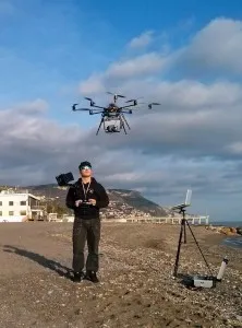
The MIRAMar team is developing a new method for monitoring beaches using small, remote-controlled drones, each equipped with a Canon camera. The drone flies at heights of 80 meters and is able to photograph a 200 meter stretch of beach in less than eight minutes. Rovere and Casella launched MIRAMar in Italy, where they fly the drone over a stretch of beach along the Mediterranean Sea. The scientists then create a digital, three-dimensional version of the beach from the images captured by the drone using computer software that makes measurements from photographs.
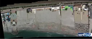
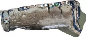
Their image of the beach is then combined with sea state observations and data such as wave direction, wave height and current wave speed from a hydrodynamic computer model, coupled with another computer model that deals with sediment transport. Rovere and Casella use this information to create a time series of how the beach has evolved and how it might change in the future. The final outputs of their computer models show patterns of erosion and accretion along the shore, and the severity of coastal changes.
With nearly 70 percent of the shorelines worldwide eroding, Rovere and Casella hope that this new method of observing shorelines will provide more timely and useful information for coastal managers. “We need high-accuracy surveys repeated at short time intervals, like those done by the drones, in order to understand how coastal areas are evolving,” Casella said.
“This is an exciting field to be in,” Rovere said. “Especially if you think that few years ago this technology was still largely inaccessible. The use of drones for environmental monitoring is growing rapidly and is being applied, as an example, to detect changes in tree cover or to monitor the evolution of landslides. The ease with which drones are deployed also allows scientists to rapidly respond to extreme weather events and learn the extent and severity of damage.”
As discovered recently at Lamont-Doherty, small drones can also be deployed for fun. On a clear and cold January day, Rovere and Casella flew the drone over the Lamont-Doherty campus in Palisades, N.Y. and recorded aerial views of the buildings and grounds, and the Hudson River beyond. Check out their video below.
To learn more about MIRAMar, visit the project website and follow Alessio Rovere (@alessio_r_ ) on Twitter.
MIRAMar is funded by the PO CRO European Social Fund, Regione Liguria 2007-2013 Asse IV Capitale Umano/Human Capital; project partners are the University of Genoa, SEAMap srl and DHI Italy.