Going Deep for Science
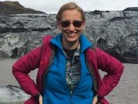
Bridgit Boulahanis, a marine geophysics graduate student at Lamont-Doherty Earth Observatory, prepares to head out on her first research cruise exploring the seafloor with underwater vehicles.

By Bridgit Boulahanis
“You are the future of deep submergence science,” mentors Dan Fornari and Cindy Van Dover tell our group of 24 ocean scientists gathered for our first pre-cruise meetings for the University-National Oceanographic Laboratory System (UNOLS) Deep-Submergence Science Leadership Cruise. Deep submergence science can mean a plethora of things, and this is reflected in the varied interests and goals of our group. Present in the room are Ph.D. students aiming to snatch octopuses from their deep-sea homes, postdoctoral researchers hoping to measure near-bottom ocean currents, associate professors attempting to record the sounds made by methane bubbles as they seep out of the seafloor, and researchers of many career stages and scientific interests in between.
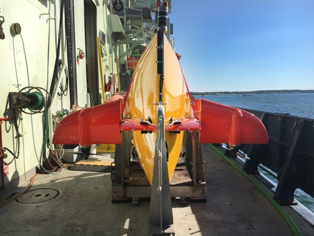
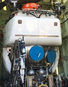
We’ll have some help in the deep, and we’re all pretty excited about it: This training cruise aims to give early career scientists experience with two deep submergence assets—Alvin, a Human Occupied Vehicle (HOV) that can carry two scientists at a time to the ocean floor, and Sentry, an Autonomous Underwater Vehicle (AUV) that can roam for hours, collecting images and data. The scientists all came aboard R/V Atlantis this week with data collection goals designed to use these incredible machines while advancing science.

Alvin is famous for its role in exploring the wreckage of the RMS Titanic, but is an icon among scientists for its unique direct observation opportunities and sample collection capabilities. Alvin’s maneuverable arms can grab rocks, corals, and critters, and it has a variety of sensors to pick up information about the water surrounding the submarine. Of course, the draw goes well beyond data—scientists who strap themselves into Alvin for a dive get to directly experience the environment that our data describes. It’s often compared to an astronaut’s trip into space. Alvin gives scientists the opportunity to be immersed in the world we have dedicated our lives to but otherwise cannot explore first-hand.
Sentry, though less well known than Alvin, is no less powerful a tool for scientific discovery. It can be illustrative to think of Sentry as a submarine drone—scientists plan out missions in advance and provide Sentry with a map of locations for data collection before launching the AUV to conduct operations without human intervention for upwards of 40 hours. Sentry can function at depths up to 6,000 meters, and can be customized to collect data for versatile science goals. For a geophysicist, this is where the real excitement lives. We’ve all heard the statistic that less than 5 percent of the ocean has been explored, and Sentry has the power to change that, creating maps and taking photos at a resolution and scale that is impossible by almost any other means. Every time Sentry is launched we make another dent in that 95 percent left to be explored, and so every mission feels like a battle won for science. We will be launching Sentry at night to collect high-resolution photos and data mapping the seafloor. That valuable data will then inform Alvin’s later dives.

My role on this cruise is as Sentry’s coordinator, so I will be helping plan missions and process the mapping data that Sentry collects. I will also be acting as science liaison to the Sentry operations team. The first stop is a fascinating patch of seafloor called Veatch Canyon 2, where gas bubbles leach out of the seafloor and sea life has been spotted gathering. Past missions have identified corals, mussels and bacterial mats at this site, all of which are indicative of active gas seepage. We leave port at 6 a.m., and after 13 hours of transit we will arrive above our launch site—that is when my team will have to jump into action, getting Sentry overboard as quickly as possible to maximize our mapping and photo-taking time.
Stay tuned for updates on research life at sea, what it is like to work with Alvin and Sentry, and why all of this is so important for the future of marine science.
Bridgit Boulahanis is a marine geophysics graduate student at Columbia University’s Lamont-Doherty Earth Observatory. Her research utilizes multichannel seismic reflection and refraction studies as well as multibeam mapping data to explore Mid-Ocean Ridge dynamics, submarine volcanic eruptions, and how oceanic crustal accretion changes through time.
Save
Save
Save
Save
