Eyes in the Sky: Using Remote Sensing to Explore the Poles
DESCRIPTION: The polar regions are extremely dynamic with the ice constantly changing and flowing in response to forces, including climate change. Here we introduce a set of NGSS standards based education resources that empowering students with accessible and user-friendly remote sensing tools that allow them to explore, observe, and make hypotheses about our ever-changing polar regions. The resources are introduced through a video presentation by Margie Turrin, Director of Educational Field Programs and Laurel Zaima, Education and Outreach Coordinator, Lamont-Doherty Earth Observatory.
Target Audience: Grades 6-12
Note: This activity has been reviewed and approved for inclusion in the CLEAN network of climate education resources. Notes from reviewers are available on their website which may be useful in guiding teachers in their use of this resource.
Acknowledgements: We acknowledge and appreciate support from the National Science Foundation (NSF) Greenland Lakes Grant, NSF #OPP-2003464. Any opinions, findings, conclusions or recommendations expressed in this material are those of the authors and do not necessarily reflect the views of the National Science Foundation (NSF).
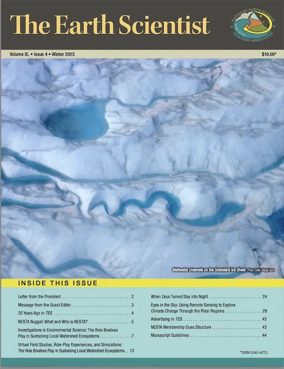
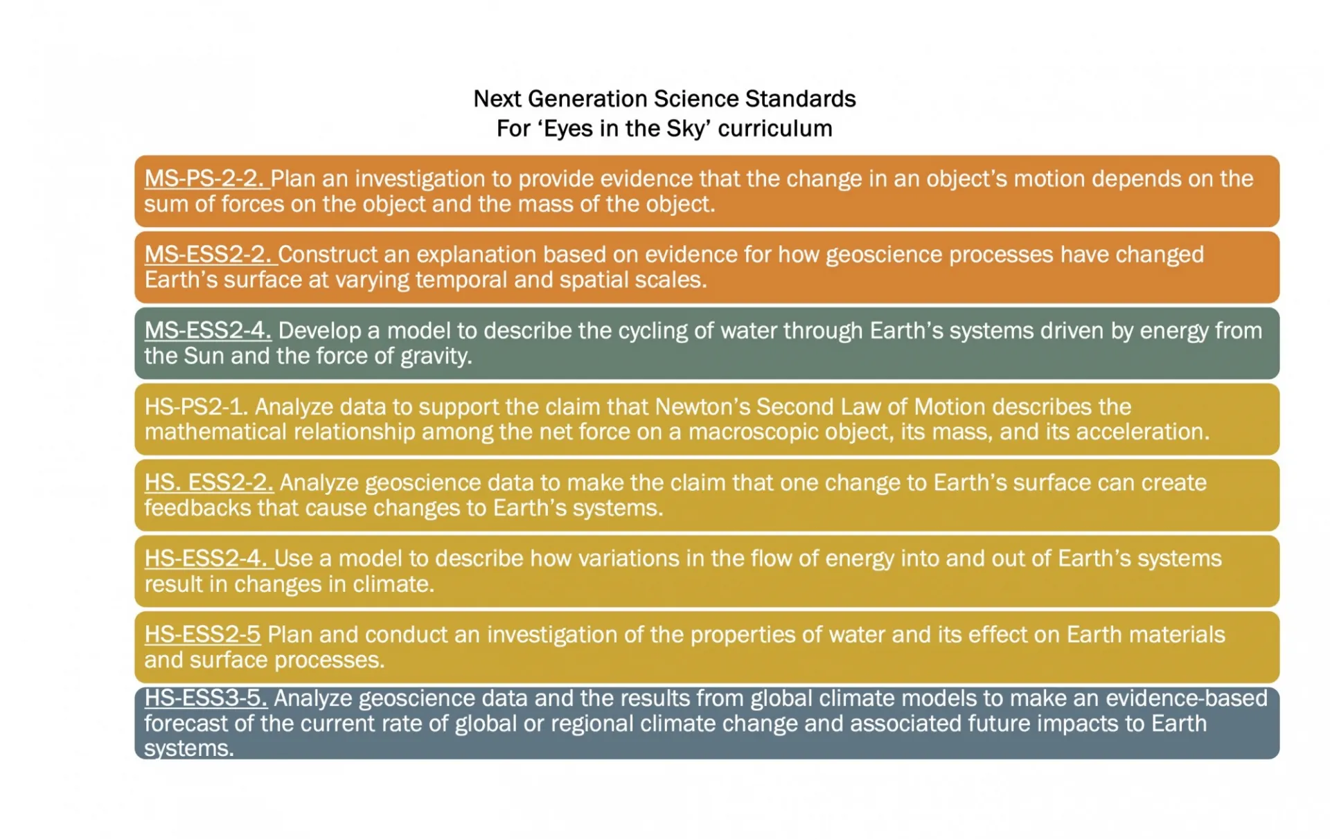
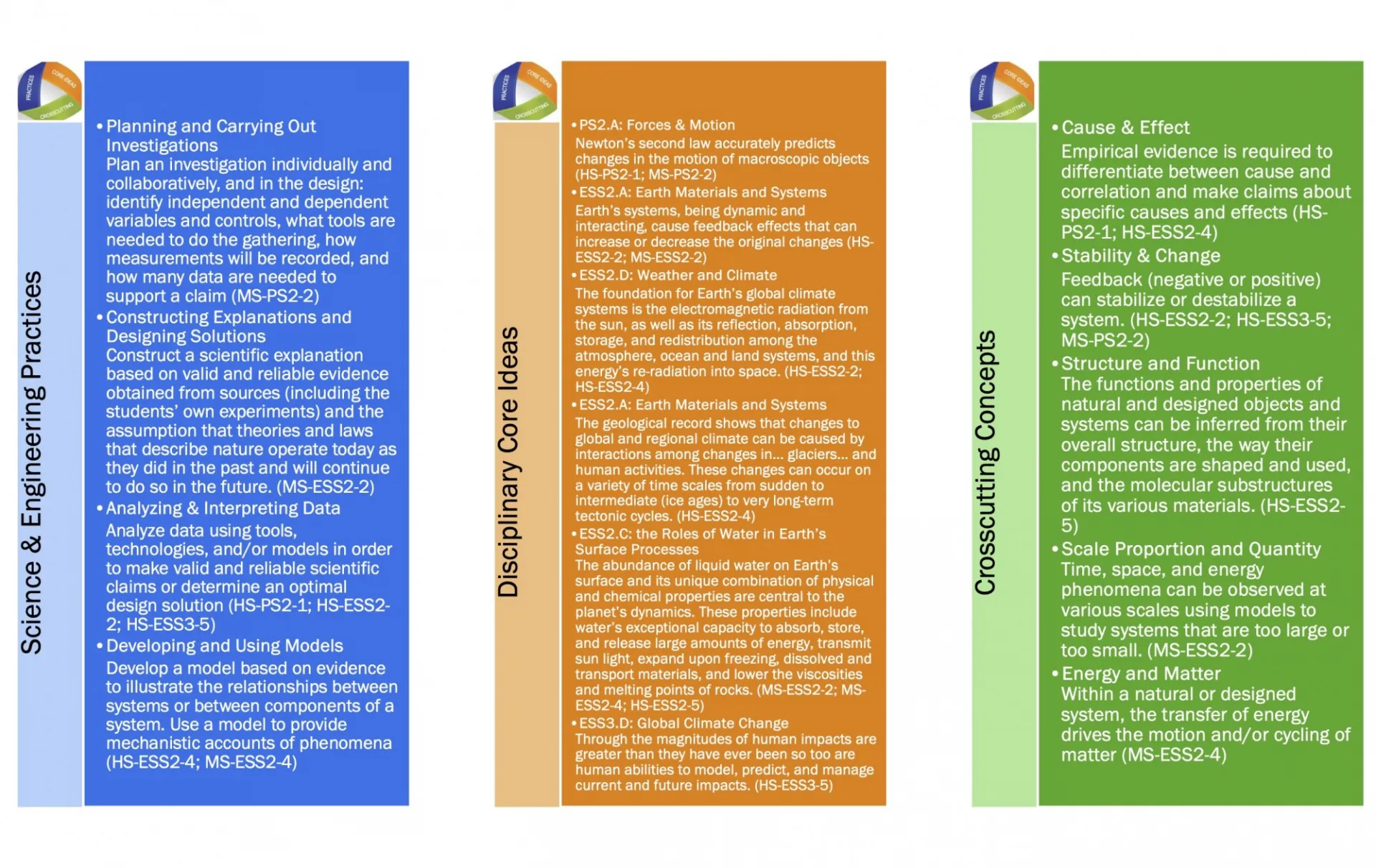
The article linked above is a complete guide to the following activity that introduces remote sensing tools to the classroom to study changes in ice in the polar regions. Published in the National Earth Science Teachers Association Winter 23-24 version of The Earth Scientist, it iis matched to Next Generation Science Standards for both Middle and High Schools.
Activity Instructional Materials
A pdf of the slide deck used in the presentation that can be downloaded for use in the classroom to lead the education activities.
- Classroom Version
- Notes version of the slidedeck for teachers
Ablation: processes that remove snow or ice from the surface of a glacier or ice area
including sublimation, fusion, melting, or evaporation.
Albedo: surface reflectivity measured on an index from 0-1, scaled low to high. Ice has a high albedo, reflecting solar radiation away from Earth. Water is darker with a lower
index.
Equilibrium Line/Ablation Line: the line/zone that separates on the ice sheet that is accumulating (gaining snow/ice) and the side that is ablating (losing snow/ice).
Firn: granular snow that has survived at least a full seasonal cycle, generally in the upper 40-120 meters of the glacier where it has not yet been compressed into ice, but the thickness can vary by location.
Floe: a large cohesive or unbroken sheet of floating ice, measuring larger than 20 meters (22 yards) across.
Fracture: a break or splitting through the ice that may vary in length from a few yards or meters, to several miles or kilometers. Fractures provide a weakness area in the ice.
Glaciers: made of fallen snow that has compressed into large thickened ice masses over many years. Glaciers form when snow remains year-round in an area, collecting and
compressing over time into ice.
Grounding Line: the point where an outlet glacier transitions from being grounded to the bedrock to floating over the open body.
Ice Sheets: expansive permanent dome shaped mass of ice exceeding 50,000 square kilometers, formed from a coalescing of glaciers. Currently there are two ice sheets in the world, one in Greenland and one in Antarctica (although some refer to Antarctica as two ice sheets - East and West).
Ice Stream: large glaciers that flow quickly as they drain a large section of the ice sheet.
Mélange: a mixture of sea ice, icebergs, broken ice chunks, and snow without a clearly defined floe structure. Forms from natural fracturing at the ice front.
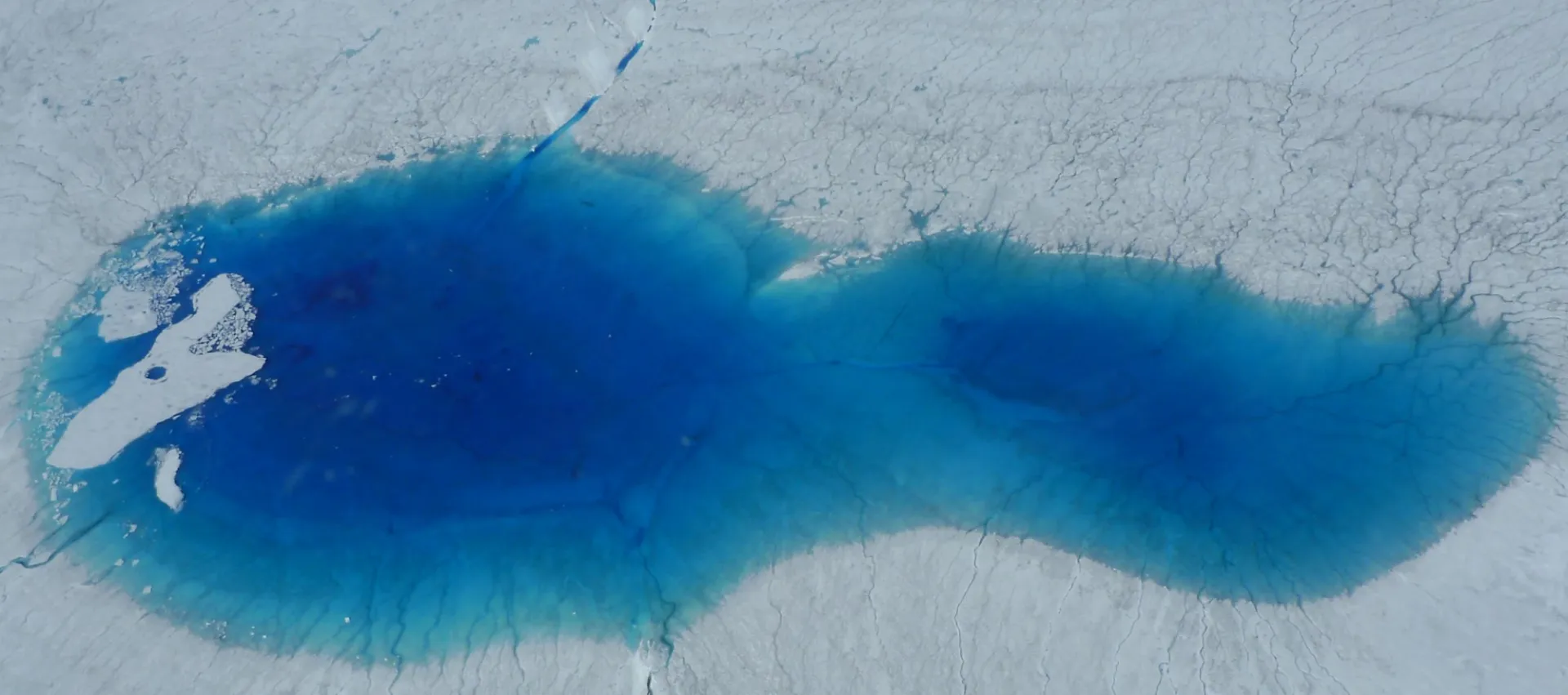
Moulin: a narrow tube, hole or crevasse in the ice formed by the weight of surface meltwater collected at the surface, transporting it quickly down to the ice base where it can lubricate the bed. In moments meltwater transported through moulins can create the same effect as 10,000 years of surface ice melt.
Polar Amplification: a phenomenon where the polar regions experience faster rising temperatures than other latitudes due to climate forcing and a series of feedbacks.
Supraglacial Lakes: meltwater lakes that occur on the surface of the ice.
Student worksheets: The worksheets are used to collect data throughout their exploration of the online tools and images (Lessons 3-5).
- Lesson 3: Exploring Global Glaciers. This worksheet includes links to the different online tools used in activity one, and are used to support them as they form and amend their overarching hypotheses.
- Lesson 4: Explore Time Lapse. Supports the students use of this tool in exploring the Sermeq Kullaleq glacier 1984 forward.
- Lesson 5: Exploring Greenland’s Ice Surface, Water and Ice. Uses claims, evidence and reasoning to support the students observations of change.
- A step-by-step walk through of the full activity for teachers with links to additional materials and resources.
- Teacher versions of the student worksheets with answers and teaching tips included:
- Lesson 3: Exploring Global Glaciers
- Lesson 4: Exploring Time Lapse
- Lesson 5: Exploring Greenland’s Ice Surface, Water and Ice
- The complete animation of the lake propagation up the ice sheet by Amber Leeson that is included in the presentation so you can share it in your classroom
- Optional: hydrofracturing sequencing activity developed to support understanding of how hydrofracturing develops and propogates through the ice.
We have found that a good introduction for students to ice and ice movement is this set of activities that is done with a material we call glacier goo, a slime-like activity that mimics the viscosity and movement of ice.
These activities can be done in your class with students exploring ice properties that control ice movement in the polar regions. Directions for making goo, and for the actvities is linked below as well as 3 short videos (~ 1 min each) that review a few of the activities with the key points to take away. Additionally we linked a supporting demonstration video that reviews each activity with teaching points.
- Full packet of Bergy Bits: Glacier Activities including the recipe for Glacier Goo and full descriptions.
- Set of short ~ 1 minute Videos:
- Gravity - a demonstration of ice's constant movement, flowing under the tug of gravity.
- Basal Friction - a look at how ice interacts with the surface at its base
- Channel Friction - a look at how ice interacts along its edges as it flows over land forms.
- Optional: supporting video that introduces all the Bergy Bits activities through demonstration and discussion.
Additional optional activities and labs that relate to glacier flow: